Rare Books
Iron, railroad, canal and coal map of Pennsylvania, &c
Image not available
You might also be interested in
Image not available
Railroad, canal, iron and coal map of Pennsylvania, &c showing the relative position of the various anthracite and bituminous coal fields the railroads, canals and navigable waters by which they are connected forming their respective avenues to market also the furnaces, rolling mills, bloomeries and forges of Pennsylvania and adjoining states
Visual Materials
No old shelf mark. A detailed map showing oil regions around northwest and southwest Pennsylvania in addition to coal mining regions. Note: Phillips 684 (1867 ed.). Prime meridian: Washington. Relief: no. Projection: Cylindrical. Printing Process: Lithography.
ephMPPA0007

Map of the Cumberland Coal Region in Alleghany County, Md showing the lands of the Cumberland Coal & Iron Co. with the various outlets to the Baltimore and Ohio Rail Road and Chesapeake and Ohio Canal
Rare Books
The "Big Vein" is shaded, Cumberland Coal lands outlined in red. Mason Dixon Line runs along north edge of the property shown. MS note: 81928. Prime meridian: GM. Relief: hachures. Graphic Scale: Feet. Projection: Plane. Printing Process: Lithography. Verso Text: MS note: Cumberland Coal. Notes to self: Cumberland Coal and Iron Company incorporated in 1841. Ackerman Lith in OCLC - 1847 -1858
81928
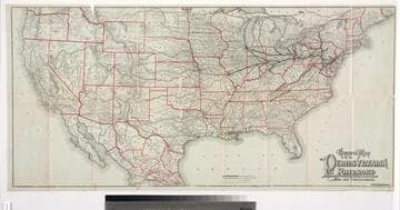
General map of the Pennsylvania Railroad and its connections
Visual Materials
Image of a map of most of the continental United States and part of Mexico showing the main routes and connecting lines of the Pennsylvania Railroad, with routes and railroad stations named; map verso contains 16 panels with railroad timetables, promotional descriptions, a vignette of the interior of a Pennsylvania Railroad Dining Car with well-dressed diners being served by African-American servers, a vignette of a Pullman sleeping car with passengers sitting in seats, including a woman reading and a girl, and inset with an image of a sleeping birth and a man shining shoes; folding map cover contains a vignette of a train on the Horseshoe Curve in the Allegheny Mountains and an American eagle with wings displayed standing on a shield with an "E Pluribus Unum" banner.
priJLC_TRAN_001061
Image not available
Report on the iron smelting coals of southern Indiana : adjacent to the Indiana mineral railway
Rare Books
47575