Visual Materials
Part of the Marquise [i.e. Marquez] Home, Santa Monica

You might also be interested in

A bit of the Old Graveyard, Santa Monica
Visual Materials
Image of graves and crosses in the Pascual Marquez family cemetery on the land of the former Rancho Boca de Santa Monica, which is now present-day Santa Monica Canyon, California.
photCL_555_06_149

The Old Road and Burial Ground, Santa Monica Canyon
Visual Materials
Image of a dirt road leading to the Pascual Marquez family cemetery on the land of the former Rancho Boca de Santa Monica, now present-day Santa Monica Canyon, California.
photCL_555_06_154

A busy day at Santa Monica Canyon Bath House, Cal
Visual Materials
Image of automobiles parked next to the Santa Monica Canyon Bath House on July 4, 1916, in Santa Monica Canyon, California. Signs on the north side of the building read "Santa Monica Canyon Bath House," and "F.E. Bundy" (owner of the bath house), with a sign on the beach at right "Watch Santa Monica Canyon Grow."
photCL_555_01_1291

Ted's Grill advertisement on man with stilts, Santa Monica Canyon
Visual Materials
Image of man on stilts wearing a Ted's Grill advertisement alongside automobiles stopped in traffic in Santa Monica Canyon. The restaurant was located at 146 Entrada Drive, Santa Monica, California. The advertisement reads "turn right for Ted's Grill steaks!"
photCL_555_09_114_1

Beach Road north of Santa Monica, Cal
Visual Materials
Image of the Beach Road north of Santa Monica, California (in present-day Pacific Palisades), with the Japanese fishing village next to the Long Wharf at upper right. The Santa Monica Canyon Beach House can be seen at the mouth of the canyon beyond the wharf, with the beaches of Santa Monica and the bluffs farther south.
photCL_555_09_91
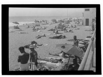
Santa Monica Canyon State Beach
Visual Materials
Image of people in bathing suits on the beach at Santa Monica Canyon State Beach in Santa Monica, California.
photCL_555_06_2151