Visual Materials
In Topanga Canyon

You might also be interested in

At the entrance to The Topanga
Visual Materials
View of a canyon, most likely Topanga Canyon, which runs through the Santa Monica Mountains and ends at Santa Monica Bay.
photCL_555_06_159
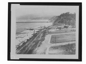
F.E. Bundy bathhouse at Santa Monica Canyon
Visual Materials
Image of the F.E. Bundy bathhouse on the beach at the mouth of Santa Monica Canyon in Santa Monica, California. The Pacific Electric tracks to Long Wharf are seen in the distance and Mayberry Road is in the foreground.
photCL_555_09_111

Pacific Palisades looking up to Topanga
Visual Materials
View looking down at the Roosevelt Highway (later Pacific Coast Highway) with the Pacific Ocean, mountains, beach, and automobiles visible along the coastline in Pacific Palisades near Topanga Canyon.
photCL_555_01_775

Summit, Topanga Canyon, Cal. Elevation 1560 Ft
Visual Materials
Image of automobiles parked near a shop with people looking at the view from the summit of Topanga Canyon Boulevard in Topanga, California.
photCL_555_01_1719

Bird's-eye-view of coastline, Pacific Palisades, California
Visual Materials
Image of a bird's-eye-view of the beach, mountains, and coastline along the Santa Monica Bay, with the Bel-Air Bay Club buildings visible at center, with the lower clubhouse on the beach and the upper clubhouse in the hills, as seen from Pacific Palisades, California, looking north towards Malibu.
photCL_555_06_2562

Topanga Canyon grade
Visual Materials
Image of two men standing in front of an automobile on Topanga Canyon Boulevard in Topanga, California, with a street sign that reads "Caution Topanga Canyon Grade - many curves ahead drive with care Auto Club of So. Cal."
photCL_555_01_1744