Visual Materials
Map of the State of Pennsylvania, by Reading Howell, MDCCXCII (1792)
You might also be interested in
Image not available
[A Map of Pennsylvania / by Reading Howell]
Visual Materials
Kashnor notes, "The first issue of Howell's map printed in America. It is exceedingly rare." Title from State 2, RB # 093:572. Prime meridian: Philadelphia. Relief: hachures. "To the Legislature and the Governor of Pennsylvania This Map is respectfully Inscribed by Reading Howell." "J. Trenchard Sculp." Graphic Scale: Miles. Projection: Cylindrical. Watermark: J. Honig & Zoonen Fleur-di-lis over J. H & Z. Printing Process: Copper engraving. Verso Text: MS notes: 725/Mus Cat. #105 39
105:725 M
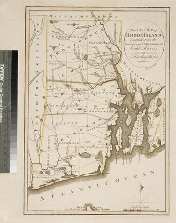
State of Rhode Island; compiled from the Surveys and Observations of Caleb Harris
Visual Materials
Kashnor notes, "The first issue of this map [1796], second issue was in 1818." McCorkle dates as 1795 and gives appeared in information. Wheat & Brun note state 1. MS notes: 581 Mus. Col. #93. Relief: no. Graphic Scale: Miles. Projection: Plane. Watermark: Device. Printing Process: Copper engraving. References: McCorkle R795.2; Wheat & Brun 250, state 1..
093:581 S
Image not available
State of South Carolina from the best Authorities, By Samuel Lewis. 1795
Visual Materials
Kashnor notes, " Shows the old roads and pathways." Mathew Carey was active in Philadelphia per Rosenthal. See also Wheat & Brun 603. See also 093:384M for later version of this map. Prime meridian: London, Philadelphia. Relief: pictorial. Graphic Scale: Miles. Projection: Mercator. Printing Process: Copper engraving. References: Wheat & Brun 601. Verso Text: MS note: 383.
093:383 M
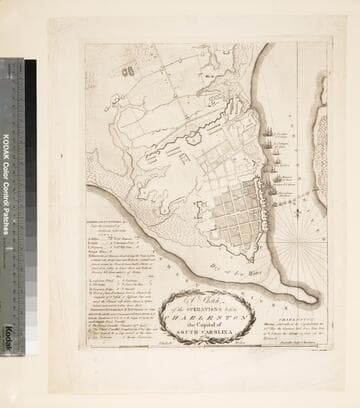
Sketch of the Operations before Charleston the Capital of South Carolina 1780
Visual Materials
Kashnor notes, "Shows the British warships bombarding the fort, and gives particulars of the forts, batteries, &c. of the opposing armies. 'Having surrendered by Capitulation the 12th May the Garrison laid down their Arms at I betwenn the Abbatis in front of the Hornwork.' Probably the earliest example of map engraving executed in South Carolina." [Ships shown are American and French, per "Dictionary of American Naval Fighting Ships."] This map State II per Wheat & Brun who identify published information, date. LC record shows Thomas Abernethie opened engraving & printing shop in Charleston, SC, ca. 1785. MS notes: 85 Mus. Col. #105 (on backing). Relief: hachures. Graphic Scale: Miles, statute. Projection: Plane. Watermark: Crowned shield. Printing Process: Copper engraving. References: Wheat and Brun 595. Verso Text: MS note: 85.
105:085 M
Image not available
Plan of Cape Breton, &c Fort Louisbourgh, &c
Visual Materials
Kashnor notes, "A very rare map, issued probably in Boston soon after the taking of Louisbourg by Pepperell." Kershaw suggests Thomas Johnston as map author as does Wheat & Brun. (Wheat and Brun refer to Museum Book Store catalog, this map.) Lower map detail of Louisbourgh defenses and British forces. MS note: 291 (on backing).. Prime meridian: London. Relief: no. Projection: Cylindrical. Watermark: I-ro Pa-- seated figure, sun with face and rays. Printing Process: Copper engraving. Other Features: Sub-maps. References: Kershaw 893; Wheat & Brun 71.. Verso Text: MS note: 291 (on backing)..
093:291 S
Image not available
Map of the Country betwen Albemarle Sound and Lake Erie, comprehending the whole of Virginia, Maryland, Delaware and Pennsylvania, with parts of several other of the United States of America. Engraved for the Notes on Virginia. The country on the eaternside of the Alleganey Mountains is taken from Fry and Jefferson's Map of Virginia, and Scull's map of Pennsylvania, which were constructed manily on actual survey; that on the westernside of the Alleganey, is taken from Hutchins, who went over the principal water courses, with a compass and log line, correcting his work by observations of latitude: additions have been made where they could be made on sure ground
Visual Materials
Kashnor notes, "Shows a particularly good map of the Ohio country where it is named 'a new state.'" Prime meridian: Philadelphia. Relief: pictorial. Graphic Scale: Miles. Projection: Cylindrical. Printing Process: Copper engraving. Verso Text: MS notes: 521 Mus. cat. 93.
093:521 M