Visual Materials
Chili
You might also be interested in
Image not available
Outlines of the Physical and Political Division of South America: Delineated by A. Arrowsmith partly from scarce and original documents, published before the year 1806 but principally from manuscript maps & surveys made between the years 1771 and 1806, corrected from accurate astronomical observations to 1810
Visual Materials
Possible duplicate of 105:854. Submaps: Entrance to the River Orinoco [with sailing directions];Map of the Orinoco River; Patagonia and Tierra del Fuego; Port of Angostura or St. Thome.. Prime meridian: GM. Relief: hachures. Graphic Scale: Miles. Projection: Cylindrical. Printing Process: Copper engraving. Other Features: Sub-maps. Verso Text: MS notes: 617 South America & section note..
093:617 M
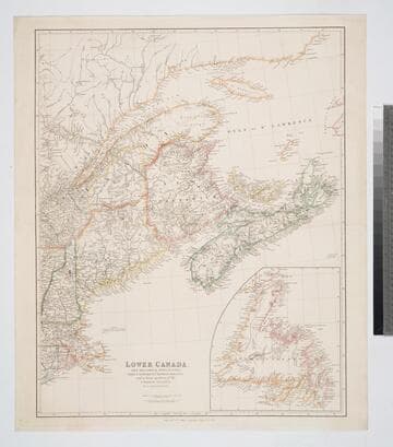
Lower Canada, New Brunswick, Nova Scotia, Prince Edwards Id. Newfoundland, and a large portion of the United States
Visual Materials
Kashnor notes, "Shows most of New England and Maine, showing the two boundaries claimed by England and United States." Submap of Newfoundland. Prime meridian: GM. Relief: hachures. Graphic Scale: Miles, Leagues (Canadian). Projection: Pseudocylindrical. Printing Process: Copper engraving. Other Features: Sub-maps. Verso Text: MS note: 137.
093:137 M

Jamaica from the latest surveys; Improved and Engraved by Thomas Jefferys Geographer to the King
Visual Materials
Two insert maps. See also 093:795M for an earlier version. Submap: Anchorage at Savanna la Mar & Bluefields; Harbour of Kingston aand Port Royal.. Prime meridian: GM. Relief: hachures. Graphic Scale: Miles, leagues. Projection: Cylindrical. Printing Process: Copper engraving. Other Features: Sub-maps. Verso Text: MS note: 796.
093:796 M
Image not available
Chart of West Falkland Island, from an Actual Survey by Lieut. Thos. Edgar of the Royal Navy, in the Years 1786 & 1787
Visual Materials
Submap: Chart of Falkland Islands.. Prime meridian: GM. Relief: hachures. Graphic Scale: Leagues. Projection: Plane. Printing Process: Copper engraving. Other Features: Sub-maps. Verso Text: MS notes: 657 22.
093:657 M
Image not available
Peru
Visual Materials
"Neele sculpt. 352 Strand." Submap: Coast below 16 deg.. Prime meridian: GM. Relief: hachures. Graphic Scale: Miles, leagues. Projection: Cylindrical. Printing Process: Copper engraving. Other Features: Sub-maps. Verso Text: MS note: 934.
105:934 M

General Plan of the Harbours, of Port Royal and Kingston Jamaica with the Channels leading thereto and the Kays and Shoals adjacent Including Wreck Reef
Visual Materials
Two insert maps. Submap: Plan of the Town and Harbour of Port Royal 1772.; Plan of Fort August and the Narrow Channel.. Relief: hachures. Graphic Scale: Miles. Projection: Plane. Printing Process: Copper engraving. Other Features: Sub-maps. Verso Text: MS note: 793.
093:793 M