Visual Materials
A New Plan of the Island of Grenada from The Original French Survey of Monsieur Pinel; Taken in 1763 by Order of Government, and now Published with the Addition of English Names, Alterations of Property and other Improvements to the Present Year 1796: by Lieut. Daniel Paterson, Assistant to the Quarter Master General of His Majesty's Forces

You might also be interested in

Course of the Delaware River from Philadelphia to Chester with the several Forts and Stackadoes raised by the Rebels, and the Attacks made by His Majesty's Land and Sea Forces
Visual Materials
Kashnor notes, "Shows the march of Cornwallis from Bilingport to Philadelphia in November, the colonial fleet burning off Glocester, and the boom across the river at Bilingport." Submap: A Plan of Fort Mifflin on Mud Island, with the attacks made by the King's Troops and Vessels. Crossectional views of "Stackadoes," sunken frames filled with rocks to impede navigation.. Relief: hachures. Graphic Scale: Miles. Projection: Plane. Watermark: Seal?. Printing Process: Copper engraving. Other Features: Sub-maps.
105:091 M

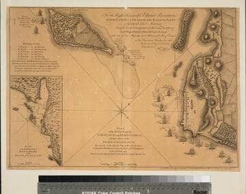
A Plan of the Posts of York and Gloucester in the Province of Virginia, Established by His Majesty's Army under the Command of Lieut. General Earl Cornwallis, together with The Attacks and Operations of the American and French Forces, Commanded by General Washington and the Count of Rochambeau, Which Terminated in the Surrender of the said Posts and Army, on the 17th of October 1781. / Surveyed by Captn. Fage of the Royal Artillery
Visual Materials
Kashnor notes, "Exceedingly rare, and only a few copies known. The slip map shows the position of the British lying across the Great South Road to Hampton, while the map shows the first and second parallel as Washington gradually closed in on Yorktown. This is probably the finest war plan of the action which swept away all hopes of the success of British arms, and was the crowning victory for American Independence." Contains submap of Chesapeake Bay. [Many characteristics of Des Barres maps, but map trimmed to neatline with no mention of author.] Submap: Chesapeake Bay and vicinity.. Relief: hachures. Graphic Scale: Feet. Projection: Plane. Printing Process: Copper engraving. Other Features: Sub-maps. Verso Text: MS note: 100.
105:1000 M
Plan of the Attack against Fort Louis now Fort George, at Point a Pitre on the Island of Gaudaloupe: By a Squadron of his Majesty's Ships of War detached from Commodore Moore, & Commanded by Capt. Wm. Harman, on the 14 FRebruary 1759. Drawn on the Spot by Lieut. Col. Rycaut of the Marines
Visual Materials
Kashnor notes, "somewhat wormed." Submap: Plan of the Harbour of Point a Pitre on the Island of Guadaloupe. MS note: 777 (on backing). Relief: hachures. Graphic Scale: Yards. Projection: Plane. Printing Process: Copper engraving. Other Features: Sub-maps. Verso Text: MS note: 777 (on backing).
093:777 M

Barre et Port Charles-town levé en 1776 avec les Attaques du Fort Sulivan du 28 Juin 1776 par l'Escadre Anglaise Commandée par P. Parker
Visual Materials
Kashnor notes, "A rare map of Charlestown Harbour, copied from the English war plan issued by Sayer in 1776. This was published for the use of French navigators during the Revolution." Submap of harbor entrance. Submap - Entrée de Charles-Town Par Dessan Cape des Vaissaux au Service d. M. Laffon de la Debat Ecuyer a Bordeaux en 1777. Dimension in marine leagues.. Relief: pictorial & hachures. Graphic Scale: Miles. Projection: Plane. Watermark: Cagne(?). Printing Process: Copper engraving. Other Features: Sub-maps.
105:074 M
Image not available
Map of the Oregon Territory / by the U. S. Ex. Ex. Charles Wilkes Esqr. Commander 1841
Visual Materials
Kashnor notes, "An exceedingly rare map issued in England during the Oregon dispute. A note states that the northern part of the map contains the latest information of the Hudson's Bay Company, and the eastern side of the Rockies that of Lieut. Fremont. The northern boundary of the territory is at Fort Simpson on Dixon's Entrance." Contains submap of the Columbia River. EX. Ex. is "Exploring Expedition." Submap: Columbia River reduced from a survey by the U. S. Ex. Ex. 1841. Prime meridian: GM. Relief: hachures. Graphic Scale: Miles. Projection: Azimuthal. Printing Process: Copper engraving. Other Features: Sub-maps. Verso Text: Ms note: 706 two sections with marbled end paper..
105:706 M
Image not available
To His Most Excellent Majesty King William IV: This Topographical Map of the Districts of Montreal, Lower Canada
Visual Materials
This map is from the same series as 105:758. Kashnor notes, "A very fully detailed map, indicating ferries, bridges, corn mills, saw mills, iron works, Churches, colleges, telegraphs, &c. A very fine impression of Bouchette's famous map." Submap: Continuation of the Rideau Canal.. " Exhibiting the New Civil Division of the Districts into Counties Pursuant to a Recent Act of the Provisional Legislature; also a large section of Upper Canada, traversed by the Rideau Canal. Is With His Majesty's gracious and special Permission Most humbly and gratefully Dedicated by His Majesty's most devoted and loyal Canadian Subject, Joseph Bouchette, His Majesty's Surveyor General of the Province and Lieut. Colonel C.M." "Engraved by J & C. Walker 47 Bernard Street, Russell Square." Relief: hachures. Graphic Scale: Miles, Leagues. Projection: Plane. Printing Process: Copper engraving. Other Features: Sub-maps. Verso Text: MS note: 771 (on backing).
105:771 M