Visual Materials
Plan of the Town and Harbour of San Juan de Puerto Rico

You might also be interested in
Image not available
Plan of the Town and Harbour of Halifax in Nova Scotia
Visual Materials
Kashnor notes, "A small but scarce plan." MS note: 273 (on backing). Relief: hachures. Graphic Scale: Miles. Projection: Plane. Printing Process: Copper engraving. References: Kershaw 824. Verso Text: MS note: 273 (on backing).
093:273 S

Plan of the Aguada Nueva de Puerto Rico
Visual Materials
Kashnor dates as ca. 1760. "Plate 32. (upper left) Page 97. (upper right)" Ms note: 753 (on backing). Relief: hachures. Graphic Scale: Miles. Projection: Plane. Printing Process: Copper engraving.
105:753 S
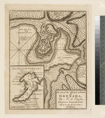
Plan of the town & fort of Grenada / by Mr. de Caylus, Engineer General of the French Islands
Visual Materials
Kashnor dates as ca. 1760. Jolly notes publication date as December 1762. Submap of island. Submap: The Isle of Grenada. MS note: 404 (on backing). Relief: hachures. Graphic Scale: Fathoms. Projection: Plane. Printing Process: Copper engraving. References: Jolly, Brit. Periodicals LOND - 219.
105:404 S

Plan of the Town of Basse Terre the Capital of Guadaloupe from an Authentic Survey
Visual Materials
Kashnor notes, "Issued shortly after the attack on Basse Terre during the Old French War." MS note: 778 (on backing). Relief: hachures. Graphic Scale: Yards. Projection: Plane. Watermark: P. Printing Process: Copper engraving. Verso Text: MS note: 778 (on backing).
093:778 S

Plan of the Town and Chart of the Harbor of Boston Exhibiting a View of the Islands Castle Forts and Entrances into the said Harbour
Visual Materials
Kashnor notes, "a scarce plan." View from Chelsea to Hingham. Ms note: 67 (on backing). Prime meridian: London. Relief: no. Graphic Scale: Miles. Projection: Plane. Printing Process: Copper engraving. Verso Text: MS note: 67 (on backing).
093:067 S
Image not available
Plan of the Harbour of Chebucto and Town of Halifax
Visual Materials
Kashnor notes, "A curious map with ensigns of Gascoigne, Pilkington, Slingsby, Pickering, Musgrave, Meredith and Nova Scotia, and an engraved porcupine and two butterflies, the Orange Underwing Tyger and the White Admirable." Kashnor dates as ca. 1759. Kershaw dates from publication in 1750 and determines author. This map is known as the "Porcupine Map." Insects and porcupine. Coats of arms. MS note: 311 (on backing).. Relief: pictorial. Graphic Scale: Miles. Projection: Plane. Printing Process: Copper engraving. Other Features: Figures . References: Kershaw 813. Verso Text: MS note: 311 (on backing)..
093:311 S