Visual Materials
Chart of the Atlantic Ocean, with the British, French & Spanish Settlements in North America and the West Indies; as also on the Coast of Africa

You might also be interested in

Chart of North Atlantic Ocean with tracks of the Shipping to West Indies, North America &c
Visual Materials
Kashnor notes, "Shows the coast of North America from Hudson's Straits, locating the states on the seaboard." Shows routes of US ship Insurgent, Route of Nelson in 1805 in addition to trade routes. Also shows nonexistant "New Sea" between Hudson's Bay and Straits. Prime meridian: Ferro. Relief: no. Projection: Mercator. Printing Process: Copper engraving. Verso Text: MS note: 160.
105:160 M
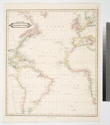
Chart of the Atlantic Ocean
Visual Materials
Kashnor notes, "Shewing the American Coast from Hudson's Strait to C. Bahias in Patagonia, and the European and African Coast from the Faeroe Islands to Cape Town." Prime meridian: GM. Relief: no. Projection: Mercator. Printing Process: Copper engraving. Verso Text: MS notes: 168 Chart of the Atlantic Ocean..
105:168 M
Image not available
Chart exhibiting the New Discoveries in the North & South Pacific Ocean, also those on the North-west Coast of America
Visual Materials
Kashnor notes, "Shows a good coastline to the North-West, and locates Port Sir Fran. Drake, Juan de Fuca Strait, Nootka Sound and other discoveries by Cook." Kashnor notes date as ca. 1780. Prime meridian: GM. Relief: no. Graphic Scale: No. Projection: Mercator. Printing Process: Copper engraving.
105:014 M
Image not available
Chart of the Atlantic Ocean, with the British, French & Spanish Settlements in North America and the West Indies; and also on the Coast of Africa / by Thos. Jeffreys Geographer to His Majesty
Rare Books
This may be Jefferys' copy of John Green's map. It has two overlays, Plate 1 is "Claims of the French in 1756 are colored in yellow." Plate II is "The French Dominions as proposed by M. de Bussy in 1761 are colored yellow and the lands proposed by M. de Bussy to be neutral are colored Green." The main map is designated as Plate III. "The Dominions ceded by France & Spain to Great Britain in 1762 are colored with a feint Red..." Prime meridian: London, Ferro. Relief: no. Projection: Cylindrical. Printing Process: Copper engraving. MS note: Published Feb. 7 1763.
295814
Image not available
North America British Possessions
Visual Materials
Kashnor notes, "Shows the northern boundary of Oregon in the latitude of Queen Charlotte Island (Lat. 54) as part of the United States." Kashnor dates as ca. 1831. XII. (upper left) Prime meridian: GM. Relief: hachures. Projection: Conic. Printing Process: Engraving. Verso Text: MS notes: 711 British North America Possessions 62.
105:711 M
Image not available
North America and the West Indies: a New Map, wherein the British Empire and its limits, according to the difinitive(sic) Treaty of Peace in 1763, are accurately described, and the Dominions possessed by the Spaniards, the French and other European States; the whole compiled from the New Surveys and Authentic Memoirs that have hitherto appeared
Visual Materials
Kashnor notes, "Shows a good map of the Illinois and Ohio country. locating Chicago. The southern boundary of the Hudson's Bay Company territories is along latitude 49, running beyond the Lake of the Woods. In the map are also located the various H. B. Co. forts and factories." Kashnor dates as ca. 1763. Submaps and treaty articles. See 105:669 for another copy. RLIN record suggests 1764 date. Cartouche with Natives. Submaps: Particular Map of Baffin and Hudson's Bay; Map of the Country between Montreal, Albany and Oswego. . Prime meridian: London, Ferro. Relief: pictorial. Graphic Scale: Miles, Leagues. Projection: Pseudocylindrical. Printing Process: Copper engraving. Other Features: CartoucheSub-mapsFigures . Verso Text: MS notes: 532 Map c.1783.
093:532 M