Visual Materials
Island of St. Domingo. Engrav'd for Luffman's Select Plans

You might also be interested in

San Domingo. Engrav'd for Luffman's Select Plans
Visual Materials
MS note: 425 (on backing). Prime meridian: London. Relief: no. Graphic Scale: Miles. Projection: Plane. Printing Process: Copper engraving.
105:425 S

Carte de l'Isle de St. Domingue avec les Routes, par P. L. Griwtonn, Ingenieur
Visual Materials
Kashnor notes, " 'Na. La Partie Espagnole est réunie a la France, par le traité de Paix conclu avec l'Espagne le 22 Juillet 1795.' In reality, San Domingo had been in the hands of the negroes since 1793." Text describing island's history.. Prime meridian: Ferro, Paris. Relief: hachures. Graphic Scale: Leagues. Projection: Cylindrical. Watermark: lettering (contains DuChamp) arrow. Printing Process: Copper engraving. Verso Text: MS note: 412.
105:412 M
Image not available
Newfoundland St. Laurens Bay, The Fishing Banks, Acadia, and Part of New Scotland. By H. Moll, Geographer. 1729
Visual Materials
Lower right is an explanation of French fishing rights and territories ceded to France by the Treaty of Utrecht. MS note: 264 (on backing). Prime meridian: London. Relief: no. Graphic Scale: Miles. Projection: Cylindrical. Printing Process: Copper engraving. Verso Text: MS note: 264 (on backing).
093:264 S
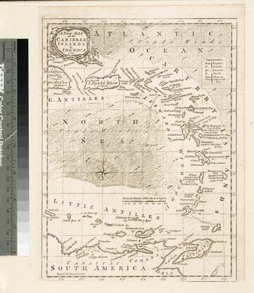
A New Map of the Caribbee Islands in America 1761
Visual Materials
Kashnor notes, "Indicates the nationalities holding the various islands at that time; also the area of the trade winds. MS note: 965 (on backing). Prime meridian: London. Relief: pictorial. Graphic Scale: Miles. Projection: Cylindrical. Printing Process: Copper engraving.
105:965 S
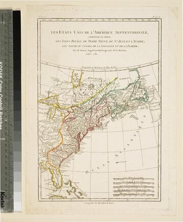
Etats Unis de l'Amérique Septentrionale, contenant en outre, Les Isles Royale, de Terre Neuve, de St. Jean et l'Acadie avec Partie du Canada, de la Louisiane et de la Floride
Visual Materials
Kashnor notes, "One of the earliest maps which acknowledges the Independence of America; the treaty was not signed until 1783." MS note: 93 (on backing). Prime meridian: Paris, Fer. Relief: pictorial. Graphic Scale: Miles, Leagues (several scales). Projection: Pseudocylindrical. Printing Process: Copper engraving.
105:093 S

An Accurate Map of the Island of St. Christophers
Visual Materials
"from an Actual Survey; Shewing the Parishes,Churches and Rivers; Also the Bays, Rocks,. Shoals, and Soundings, that Surround the Whole." "Jno. Lodge Sculp. Political Mag. March 1782" MS note: 774 (on backing). Relief: pictorial. Graphic Scale: Miles. Projection: Plane. Watermark: Two seals GR. Printing Process: Copper engraving. References: Jolly Brit. Period. Pol-48;.
105:774 S