Visual Materials
Sketch of the Country Illustrating the late Engagement in Long Island

You might also be interested in

Plan of the City and Environs of New York in North America
Visual Materials
Kashnor dates as circa. 1776. Place and appeared in from RLIN record. Colorful map. MS note: 128 (on backing). Relief: hachures. Graphic Scale: Feet. Projection: Plane. Watermark: Seal Crowned CR lettering. Printing Process: Copper engraving. Other Features: Art Work.
105:128 S

A map of Connecticut and Rhode Island, with Long Island Sound, &c
Visual Materials
Kashnor notes, "An interesting old map, published during the American Revolution, showing the old roads and towns." Kashnor dates c.1776. RLIN record notes publication in Gentleman's Magazine, November, 1776, vol. 46. Notes copper mines shown near Simsbury, CT. Place of publication assumed: Gentleman's Magazine is a London publication. MS note: 90 (on backing). Prime meridian: London. Relief: pictorial. Graphic Scale: Miles. Projection: Plane. Printing Process: Copper engraving. Verso Text: MS note: 90 (on backing).
093:090 S
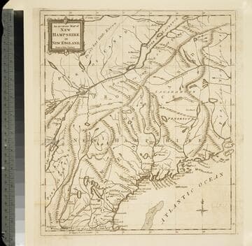
An accurate map of New Hampshire in New England, from a late survey
Visual Materials
Kashnor dates as ca. 1776. Maine is shown as part of New Hampshire. RLIN record gives place of publication, date, and appeared in information as Universal magazine of knowledge and pleasure, March, 1781. MS note: 112 (on backing). Prime meridian: London. Relief: pictorial. Projection: Cylindrical. Watermark: Seal. Printing Process: Copper engraving. References: McCorkle N781.1.
105:112 S

Carta esutta rappresentante l'Isola di Barbados
Visual Materials
Kashnor dates as c.1740. RLIN record dates as 1763, gives appeared in information. Ms note: 171 (on backing). Relief: hachures. Projection: Plane. Printing Process: Copper engraving.
105:171 S

Map of the Progress of his Majesty's Armies in NeW York During the late Campaign Illustrating the Accounts Published in the London Gazette
Visual Materials
Kashnor notes, "ShoWs the landing of Lord HoWe, Aug. 22, 1776, and his subsequent movements." Kashnor dates [1776]. MS note: 113 (on backing). Relief: pictorial. Graphic Scale: Miles. Projection: Plane. Printing Process: Copper engraving.
105:123 S

A new and accurate map of New Jersey, from the best authorities
Visual Materials
RLIN reference gives author, place of production, and notes this map is from Universal Magazine, v. 66, June 1780. Kashnor dates as circa 1780. MS note: 113 (on backing). Prime meridian: London. Relief: pictorial. Projection: Mercator. Watermark: Seal. Printing Process: Copper engraving.
105:113 S