Rare Books
Corporate ownership map and operating chart of railroads owned and solely or jointly controlled by Southern Pacific Company
You might also be interested in
Image not available
Map of Nevada / Southern Pacific Company
Rare Books
Alt. title on verso. Verso contains text describing the state. Place index in surround. Prime meridian: GM. Relief: no. Graphic Scale: Miles. Projection: Polyconic. Printing Process: Lithography. Verso Text: "In the great central portion of the State the summers are pleasant..." MS note: 254053.
254053
Image not available
Map of Arizona and New Mexico / issued by the Southern Pacific Lines
Rare Books
Alt. title from verso. Verso contains information on both states in printed form. Prime meridian: GM. Relief: shaded. Graphic Scale: Miles. Projection: Polyconic. Printing Process: Lithography. MS note: 254052 1916.
254052
Image not available
Geographically Correct Map of the United States issued by Union Pacific Railroad
Rare Books
A map to show the various Army camps, Airbases, and Naval bases at the start of World War II, and how the Union Pacific connected to many of them. Submaps: Union Pacific Railroad connecting lines over Atlantic Ocean; Union Pacific Railroad connecting lines over Pacific Ocean. Prime meridian: GM. Relief: no. Graphic Scale: Miles. Projection: Polyconic. Printing Process: Lithography.
243467
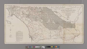
Lands granted to the Southern Pacific Railroad Company now owned by Southern Pacific Land Company in California. Sheet Four and Six
Rare Books
Stamp: "J. F. Schmitt Southern Pacific Lands." Showing a large portion of Riverside and Imperial Counties as owned by SP. MS notes: 1918/ So. Pacific. RR Co.. Prime meridian: GM. Relief: hachures. Graphic Scale: Miles. Projection: Cylindrical. Printing Process: Lithography. Verso Text: Ms nore: 254051.
254051
Image not available
Map of the Northwestern Pacific Railroad
Rare Books
The date is surmised from the amount of track in place, see Borden, Stanley. History and rosters of the Northwestern Pacific. 1949. This map was used as a sales document by the Cotati Company. The verso gives information regarding agriculture and offers land for sale. The lower section of this map is missing. Cotati Ranch is shown in MS red. Prime meridian: GM. Relief: hachures. Graphic Scale: Miles. Projection: Cylindrical. Printing Process: Lithography. Verso Text: Typed description of Cotati Ranch property. MS note: 254050.
254050
Image not available
Climatic Map of California : published by the Southern Pacific Company, 1887
Rare Books
Shows the "Mean Annual Temperature": Brown 68° to 72° ; Pink 60° to 68° ; Yellow 52° to 60° ; Green 44° to 52° ; White 30° to 44°. See 219197 for a year later copy. "Compiled by E. McD. Johnstone, S. P. Co." "From map prepared under the direction of Brig. Gen. H.G. Wright Chief of En'grs. U.S.A. Ms note: 313902. Prime meridian: GM. Relief: hachures. Graphic Scale: Miles. Projection: Cylindrical. Printing Process: Lithography. Verso Text: Southern Pacific Comparative Climatic Map of California. MS Note: 313902.
313902