Manuscripts
Plat of the Rancho Aguaje de la Centinela finally confirmed to Bruno Abila in the County of Los Angeles California

You might also be interested in

Plat of the Rancho Aguaje de la Centinela finally confirmed to Bruno Abila in the County of Los Angeles California
Manuscripts
Inset table: Meanders of the Centinela Creek. Penciled annotations & calculations. "Survey of the exterior boundaries". Hashures on both side of creek (fences?). "T 2. S.R. 14 W." middle of map. "By Seebold" lower righthand corner in pencil
mssSolano SR_Map_0002.01

Plat of the Rancho Aguaje de la Centinela finally confirmed to Bruno Abila
Manuscripts
Bordered by Rancho La Cienega y La Tijera and Rancho Sausal Redondo. Stream runs through defined area. Color highlights; pencil annotations. Includes inset of table with boundary coordinates and distances. Containing 2278 68/100 acres. "T. II S. R. XIV W." in middle of map. Surveyed under the Instructions from the U.S. Surveyor General
mssSolano SR_Map_0001

Plat of the Rancho Aguaje de la Centinela finally confirmed to Bruno Abila
Manuscripts
Adjacent T. 2 S., R. 15 W., public land and Rancho Sausal Redondo. Color highlighted Lot No. 40 T. 2 S., R. 14 W., showing markers and coordinates; table of boundaries . Book of Patents No. 1 p. 572
mssSolano SR_Box_20(01).04

Plat of the Rancho Aguaje de la Centinela finally confirmed to Bruno Abila
Manuscripts
Bordered by Ranchos Sausal Redondo, La Cienega y La Tijera. Outline with courses & distances, boundary markers
mssSolano SR_Box_20(01).03
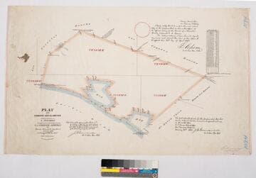
Plat of the Rancho Los Alamitos finally confirmed to A. Stearns
Manuscripts
Bordered by Los Cerritos Rancho, Pacific Ocean, Rancho Bolsa Chica, Ranchos Los Bolsas, Rancho Los Coyotes. Surveyed under the Instructions from the U.S. Surveyor General. Approved 1860 & 1861 by J.W. Mandeville (?) and L. Upson, 1867, U.S. Surveyor Generals Cal.. Colored highlights around boundaries. Includes two bays and numerous sloughs. Boundary landmarks. T. IV S.R. XII W, T IV S.R. XI W., T V S.R. XIII W., T.V S.R. XI W., T V S.R. XII W.. Inset with table of boundary coordinates and distances
mssSolano SR_Map_0006

Plat of the Rancho La Cienega o Paso de la Tijera finally confirmed to Tomas Sanchez et al
Manuscripts
Bordering Ranchos Cienega, Ballona, San Ysidero Cañada de Los Bueyes, Aguaje de Centinela (Ygnacio Machado). T 2 S.R. 14 W.,Var. 14° E.. Windsor Hills, View Park areas. Color highlighting, hachures. Insets: two tables - Meanders of the Zanja del Rodeo de Enmedio; Boundaries of the Rancho La Cienega o Paso de la Tijera.
mssSolano SR_Map_0039