Manuscripts
Rancho La Brea: township plat of survey

You might also be interested in

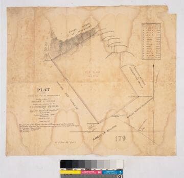
Plat of the Rancho La Brea finally confirmed to Antonio Jose Rocha
Manuscripts
Bordered by Ranchos San Antonio (or Rodeo de las Aguas), Las Cienegas, Los Felis and public land. Sixth page of document, "Rancho La Brea Patent," with color highlighting, talbe of boundary data; shows structures, courses, distances, section numbers, hachures, stations
mssSolano SR_Box_20(10).02

Los Angeles County public lands : T. 1S. R. 13-14W., T.2S. R. 13-14W., and T.3S. R. 13-14W. S.B.M
Manuscripts
Shows Ranchos Aguaje de Centinela, Rodeo de las Aguas, La Brea, Los Felis, Las Cienegas, Rincon de Los Bueyes, La Ballona, Cienega Paso de la Tijera, Sausal Redondo, San Pedro, Tajauta; City of Los Angeles, Land of W.S. Rosecrans. Showing structures, townships, section numbers, surface detail, parcel owners; color highlighting. Title supplied by cataloger.
mssSolano SR_Map_0769
Plat of the Rancho San José de Buenos Ayres
Manuscripts
Bordered by Ranchos San Antonio or Rodeo de Las Aguas, Rincon de los Bueyes, La Ballona, San Vicente; coast range of mountains. T. 1S. R. 15W. Lot No. 38. Finally confirmed to Benjamin D. Wilson. Inset: table with boundary data; Var. 13° 30' East. Faded color highlighting; dense hachures. Field notes on file as of July 2nd, 1859
mssSolano SR_Map_0162

Plat of the Rancho La Cienega o Paso de la Tijera finally confirmed to Tomas Sanchez et al
Manuscripts
Bordering Ranchos Cienega, Ballona, San Ysidero Cañada de Los Bueyes, Aguaje de Centinela (Ygnacio Machado). T 2 S.R. 14 W.,Var. 14° E.. Windsor Hills, View Park areas. Color highlighting, hachures. Insets: two tables - Meanders of the Zanja del Rodeo de Enmedio; Boundaries of the Rancho La Cienega o Paso de la Tijera.
mssSolano SR_Map_0039

Map of Survey of the Rancho Rincon de los Bueyes
Manuscripts
Bordered by public lands, Ranchos Ballona, Las Cienegas, Cienega ó Paso de la Tijera, San Jose de buenos Ayres, Rodeo de las Aguas. Incomplete copy of previous map, less detail and notation; slightly different title. Structures and surface detail.
mssSolano SR_Map_0129.02

Sketch map of Ranchos Rodeo de las Aguas and La Brea
Manuscripts
Rancho La Brea. Featuring sections 7-9; Lot No. 11 Rancho La Brea, No. 38 Rancho San Antonio or Rodeo de las Aguas. Title supplied by cataloger.
mssSolano SR_Map_0135.02