Manuscripts
Plat of the Rancho Sausal-Redondo

You might also be interested in

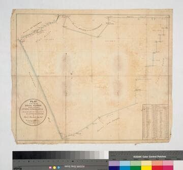
Plat of the Rancho Sausal Redondo
Manuscripts
Bordered by Shoalwater Bay, ranchos La Ballona, Cienega o Paso de la Tijera, Aguaje de la Centinela, San Pedro, Tajauta, public lands, and Los Angeles City lands. Finally confirmed to Antonio Ignacio Abila Containing 48750 02/100 Acres. Color highlighting, section numbers. Inset with table of boundary data.
mssSolano SR_Map_0260
Plat of the Rancho Sausal Redondo
Manuscripts
Bordered by ranchos San Pedro, La Ballona, Aguaje de la Centinela; Shoalwater Bay & Public lands. Finally confirmed to Antonio Ignacio Abila Containing 35880 46/100 Acres. Inset with table of boundary data. color highlighting, minor topographical details. Similar to Map 258 minus the sections detail.
mssSolano SR_Map_0259
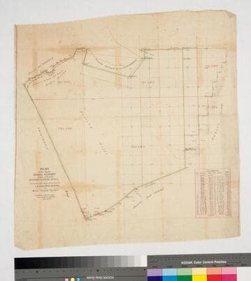
Plat of the Rancho Sausal Redondo
Manuscripts
Bordered by ranchos San Pedro, La Ballona, Aguaje de la Centinela; Shoalwater Bay & Public lands. Finally confirmed to Antonio Ignacio Abila Containing 31,600 46/100 Acres. Numbered sections with bearings, distances, color highlighting, minor topographical details: portion of the Rancho called Guaspita. Inset with table of boundary data.
mssSolano SR_Map_0258

Los Angeles County public lands : T. 1S. R. 13-14W., T.2S. R. 13-14W., and T.3S. R. 13-14W. S.B.M
Manuscripts
Shows Ranchos Aguaje de Centinela, Rodeo de las Aguas, La Brea, Los Felis, Las Cienegas, Rincon de Los Bueyes, La Ballona, Cienega Paso de la Tijera, Sausal Redondo, San Pedro, Tajauta; City of Los Angeles, Land of W.S. Rosecrans. Showing structures, townships, section numbers, surface detail, parcel owners; color highlighting. Title supplied by cataloger.
mssSolano SR_Map_0769

Plat of the Rancho La Cienega o Paso de la Tijera finally confirmed to Tomas Sanchez et al
Manuscripts
Bordering Ranchos Cienega, Ballona, San Ysidero Cañada de Los Bueyes, Aguaje de Centinela (Ygnacio Machado). T 2 S.R. 14 W.,Var. 14° E.. Windsor Hills, View Park areas. Color highlighting, hachures. Insets: two tables - Meanders of the Zanja del Rodeo de Enmedio; Boundaries of the Rancho La Cienega o Paso de la Tijera.
mssSolano SR_Map_0039

Rancho las Ciénegas : S59 - Plat of the Rancho la Cienega finally confirmed to Anuario sic Abila et al
Manuscripts
Bordered by public lands, Ranchos La Cienega y La Tijera, Rodeo de las Aguas, La Brea. Within bound document, "Rancho La Cienega Partition... Henry H. Gird et al vs. Januario Abila et al..." copy certified by numerous officials; with color highlighting, surface details, table with boundary data, courses, distances, section numbers, markers. Title supplied by cataloger.
mssSolano SR_Box_21(04).06