Manuscripts
Map of Grasshopper Street from 6th St. to Pio Pico St

You might also be interested in
Image not available
Seebold, L[othar]
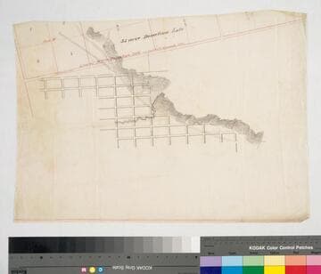
Manuscripts
Map of Grasshopper Street from 6th St. to Pio Pico St. and the Extension of Seventh Street from Grasshopper St.r to the City Limits [Blocks 24, 25, 36, 37, Hancock's Survey, with surface detail]
mssSolano

Map of a tract of land situate between Hill, Grasshopper, 9th and 12th Streets of Ord's Survey
Manuscripts
Sixth to Pico St., Main to Grasshopper St., with color highlighting, numbered parcels & owners indicated, annotations, hachures; title history. Alt title supplied by cataloger.
mssSolano SR_Map_0390

Los Angeles : Ward to Ninth Street from Pearl Street to City limits
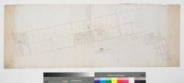
Manuscripts
Blocks 25, 37, and parts of 24 and 36, Hancock's Survey, showing parcel owners & acreage. Title supplied by cataloger.
mssSolano SR_Map_0594
Los Angeles : partial street plan
Manuscripts
Featuring part of Ord's Survey and Blocks 36-39, Hancock's Survey, with surface detail: dense hachures, line of Donation Lots in red, waterway, roads & streets. Appears to be traced from Ord's 1849 Plan of the City of Los Angeles and Hancock's 1857 map of the confirmed limits of Los Angeles. Title supplied by cataloger.
mssSolano SR_Map_0339

Map of the Subdivision of the Pryor Tract of Land
Manuscripts
P. 6 of pinned document, "Vine Street Grade," showing Blocks 3-4 between First & Turner at Alameda street; showing numbered parcels, courses, distances, owners. Alt title supplied by cataloger.
mssSolano SR_Box_32(48).07
Map showing Proposed extension L.A. and P.R.R. from Bellevue Ave. to the Junction
Manuscripts
Bellevue and New High St. to Lucille Ave. and Effie St., encompassing Avila, Montana, and Golden Gate Tracts, Childs Heights, Blocks 43, 29, 41, and 45, Hancock's Survey; black & red ink; coordinates. Alt title supplied by cataloger.
mssSolano SR_Map_0740