Visual Materials
Carte de l'Amerique Septentrionale 1754
You might also be interested in
Image not available
Carte de l'Amerique Septentrionale 1754
Visual Materials
Kashnor notes, "Shows the coast of California and the North-West to the supposed Strait of Anain." Kashnor states publication as Paris, dates as [1755] and attributes to [Jean Palariest]. See 093:167M for variant map. RLIN record identifies maker as Palairet, publication place as London, date as 1755. MS notes: Jean Palariat 1755. 13. (upper right). Prime meridian: Ferro. Relief: pictorial. Graphic Scale: Miles (naut.), leagues. Projection: Pseudocylindrical. Watermark: Crowned fluer-di-lis IV. Printing Process: Copper engraving. Other Features: Cartouche. Verso Text: MS notes: 217 .
105:217 M
Image not available
Carte Générale de l'Amérique 1754
Visual Materials
Kashnor notes, "Indicates the coast of California to the Juan de Fuca Strait." Kashnor locates publication as Paris, author as Jean Palariest. MS note: 12 Jean Palariat. Prime meridian: Ferro. Relief: pictorial. Graphic Scale: Miles (naut), leagues. Projection: Pseudocylindrical. Watermark: Crowned fluer-di-lis IV. Printing Process: Copper engraving. Other Features: Cartouche. Verso Text: MS notes: 168 12.
093:168 M
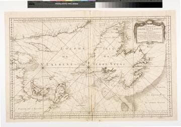
Carte Réduite du Golphe de St. Laurent Contenant l'Isle de Terre Neuve et Partie de la Coste des Esquimaux l'Isle Royale l'Isle St. Jean et celle d'Anticosti &c. Dresée au Dépost des Cartes Plans et Journaux de la Marine pour les Service des Vaisseaux du Roi. Par Ordre de M. Rouillé Ch. Comte de Jouy &c. Ministre et Secretaire d'Etat ayant le Departement de la Marine MDCCLIV
Visual Materials
Kashnor notes, "Also shows Cape Breton Island and Prince Edward Island (Isle de St. Jean)." Kashnor identifies maker as Bellin. Prime meridian: London, Lizard, Tenerife, Fer, Paris. Relief: pictorial. Graphic Scale: leagues. Projection: Mercator. Watermark: Lettering device. Printing Process: Copper engraving. Other Features: Cartouche. Verso Text: MS note: 254.
093:254 M
Image not available
Carte de l'Amerique Septentrionale
Visual Materials
Kashnor notes, "Shows California with coast reaching to the Strait of Martin d'Aquilar. locating Nle. Albion; also shows a good map of New Mexico." Kashnor dates ca. 1750. RLIN record suggests 1766. Prime meridian: Ferro. Relief: no. Graphic Scale: Leagues. Projection: Pseudocylindrical. Watermark: Chained Maltese cross. Printing Process: Copper engraving. Other Features: Cartouche. Verso Text: MS note: 216.
105:216 S
Image not available
Fleuve Saint-Laurent, Représenté plus en détail que dans l'e'tendue de la Carte
Visual Materials
Latitude and Longitude lines for Quebec marked. See 093:352 for an English version of this map which attributes the data to D'Anville. Kashnor dates this map at ca. 1760. See 105:682M for another copy. Kershaw dates as 1755. Relief: no. Graphic Scale: Leagues. Projection: Cylindrical. Watermark: Device - lettering. Printing Process: Copper engraving. References: Kershaw 625. Verso Text: MS note: 357.
093:357 M
Image not available
Fleuve Saint-Laurent, Représenté plus en détail que dans l'e'tendue de la Carte
Visual Materials
Kashnor notes, "Issued during the early part of the troubles regarding the encroachments, and supplementary to D'Anville's fine map on three sheets." Duplicate of 093:357M. Latitude and Longitude lines for Quebec marked. See 093:352 for an English version of this map which also attributes the data to D'Anville. Kashnor dates this map at [1755]. Kershaw notes as 1755. Relief: no. Graphic Scale: Leagues. Projection: Cylindrical. Watermark: Device - lettering. Printing Process: Copper engraving. References: Kershaw 625. Verso Text: MS note: 682 37.
105:682 M