Manuscripts
Centinela Los Angeles County, Cal

You might also be interested in
Image not available
Hansen, George
Manuscripts
Map 752. Centinela [subdivision map, sec. 31-33, T.2S. R.14W. S.B.M., and sec. 4-9, 16-18, T.3S. R.14W. S.B.M., showing some surface detail]
mssSolano

Los Angeles County public lands : Louis Sentous parcel
Manuscripts
Bordered by Ranchos Aguaje de Centinela, La Cienega, La Ballona, Sausal Redondo. On printed township grid: Sec. 11, 17-21, T.2 S.R. 14 W. S.B.M., with inset of boundaries in sec. 19; partly based on surveys of Aug. 28, 1874 & Jan. 23, 1883; with notations, calculations. Title supplied by cataloger.
mssSolano SR_Map_0774

Los Angeles County public lands : T.2 S. R. 14W., S.B.M
Manuscripts
Showing parts of Ranchos Ballona, Rincon de Bueyes, Aguaje de la Centinela, Sausal Redondo, Las Cienegas; public lands. showing acreages and surface detail, based on surveys of 1853-1871, with diagram of T.2 S.R. 14 W.; with color highlighting, section numbers, courses, distances, lots of notations in red ink; table of surveying history; minor surface details. Title supplied by cataloger.
mssSolano SR_Map_0766
Image not available
Thompson, George H
Manuscripts
[Public lands: T. 1S. R. 13-14W., T.2S. R. 13-14W., and T.3S. R. 13-14W. S.B.M., showing structures, surface detail, and names of parcel owners]
mssSolano
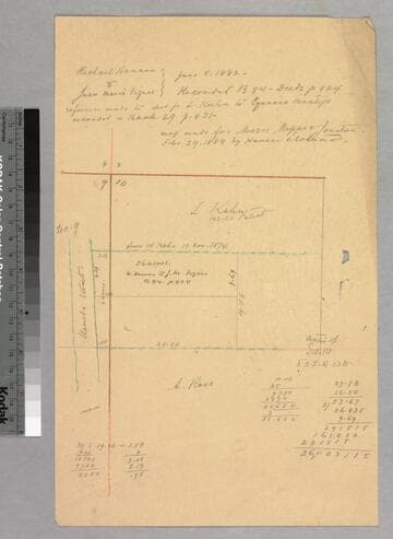
Los Angeles : Vignes/Kuhn parcel
Manuscripts
East from Alameda St., sec. 9-10, T. 2 S.R. 13 W. S.B.M.. Color highlighting, distances, property owners; pencil calculations, acreage. Title transfer info. Title supplied by cataloger.
mssSolano SR_Map_0599

Los Angeles County : public lands north and east of ranchos San José and Addition to San José
Manuscripts
Rancho Cucamonga adjacent. Rancho San Jose area: T. 1 N.R.8-9W & T. 1 S.R. 8 W. S.B.M., showing surface detail, lot numbers, color highlighting; Sierra Madre to the north, San Antonio Creek. Title supplied by cataloger.
mssSolano SR_Map_0761