Manuscripts
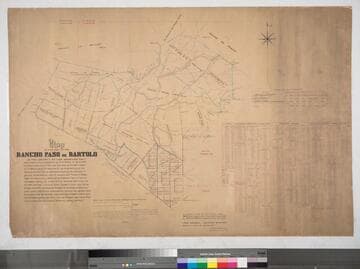
Plat of the Rancho Paso de Bartolo finally confirmed to Pio Pico

You might also be interested in
Plat of the Rancho Paso de Bartolo finally confirmed to Pio Pico et al
Manuscripts
Bordered by Ranchos Santa Gertrudes, San Antonio, La Merced, Potrero de Felipe Lugo, La Puente, San Gabriel River. Copy certified by Sherman Day, Surveyor General; Var. 15° 30' East. Inset with table of boundaries. T.2S. R.12W., T.2S. R.11W. S.B.M.
mssSolano SR_Map_0097
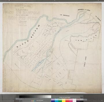
Subdivision of the Rancho Paso de Bartolo finally confirmed to Don Pio Pico
Manuscripts
Bordered by Ranchos La Merced, Potrero de Felipe Lugo, La Puente and public lands. Color highlighting; showing parcel owners, structures, topographic details, rivers [Rio Hondo, San Gabriel - not identified]; survey notes on left edge.
mssSolano SR_Map_0789

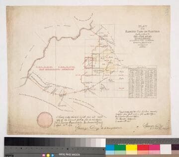
Plat of the Rancho Paso de Bartolo.; finally confirmed to Pio Pico and Juan Perez
Manuscripts
Bordered by Ranchos San Antonio, La Merced, La Puente, Santa Gertrudes; property of McFarland & Downey. Bound within document: "Field Notes and Map of the Rancho Paso de Bartolo..." (Hansen) Showing San Gabriel River, subdivided public lands, townships & section numbers, courses & distances, structures, surface details; with survey notes, table of boundaries, certification; colored inks. Alt. title supplied by cataloger.
mssSolano SR_Box_22(07).14
Map of that part of Rancho Paso de Bartolo. described in the conveyance by Pio Pico to B. Cohn
Manuscripts
Bordered by Ranchos San Antonio, La Merced, Potrero de Felipe Lugo, La Puente. Case No. 20613: Julius B. Cohn, et al. vs. Charles Prager, Jeserun, & Broderick. Extensive hachures, color highlighting, section, parcel numbers, acreage; extensive tables of allotments, with courses, distances, acreage. Shows West Whittier, San Gabriel River.
mssSolano SR_Map_0791
Map of that part of Rancho Paso de Bartolo. described in a deed from Pio Pico to B. Cohn
Manuscripts
Bordered by Ranchos San Antonio, La Merced, Potrero de Felipe Lugo, La Puente. Hachures, color highlighting, structures, parcel owners; proposed subdivision; notes re: lands of Charles Prager occupied by other parties; shows Rio Hondo, San Gabriel rivers and San Jose creek.
mssSolano SR_Map_0790

Map showing the Jesurun & Broderick lands in the Rancho Paso de Bartolo
Manuscripts
Bordered by Ranchos San Antonio, La Merced, Potrero de Felipe Lugo, La Puente. Indicates rival boundaries between Rancho Paso de Bartolo and the ranchos la Puente, Potrero de Felipe Lugo and la Merced. Color highlights; Rio Hondo, New San Gabriel rivers, and landowners indicated. Based on surveys by Solano, Solano & Stevenson, Ellis & Rowan.
mssSolano SR_Map_0107