Manuscripts
Nicolas, Pierre - lot of land

You might also be interested in
Image not available
Hansen & Solano
Manuscripts
Main & Bath Street, extended to Zanja Madre [from Arcadia to Macy St., showing structures and names of lot owners]
mssSolano
Image not available
Map of a City Lot
Manuscripts
Parcels west of Alameda street, showing courses, distances, main zanja
mssSolano SR_Box_31(29).01

Map of a Lot of land
Manuscripts
P. 2 of pinned document, "Dr. Joseph Kurtz. Lot on West side of Main Street..." Showing courses, distances, parcel owners along Main at First St.; color outlining. Alt. title supplied by cataloger.
mssSolano SR_Box_29(20).01

Map of the Subdivision of a Lot of Land granted by the City of Los Angeles to Hiram McLaughlin.; sale to P. Beaudry
Manuscripts
Showing numbered lots, courses, distances along New High Street; Jail Lot of Benjamin S. Eaton Sketches on verso. Alt. title supplied by cataloger.
mssSolano SR_Box_26(27).07

Land to be conveyed by Arcadia de Baker to the S.P.R.R. Co
Manuscripts
On the west side of San Fernando Str. to Buena Vista St.. Survey requested by Carlos Forbes. Color highlights, courses, distances with Zanja Madre, Depot Grounds. Alt title supplied by cataloger.
mssSolano SR_Map_0543.01
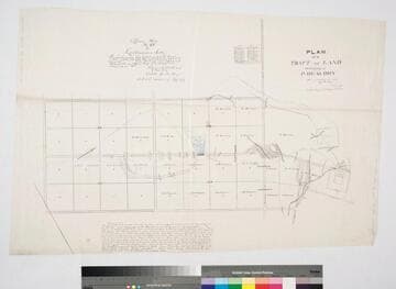
Plan of a Tract of Land belonging to P. Beaudry
Manuscripts
Original survey: June 18, 1872. ; Traced by G. B. King.. Copy of Official Map No. 69 (Canal & Reservoir St.), Blocks 27, 28, 39, 40 Hancock's Survey, with field notes for street, showing surface detail, hachures, waterbodies, parcel owners; color highlights; inset with table of bearings, distances; certified by Mayor Cristobal Aguilar (1871-1872). Verso: Reservoir Street copy of City Map 69. Alt title supplied by cataloger.
mssSolano SR_Map_0414