Manuscripts
Map of City Lots Block G Fort Hill: Map 1, Lots 14 & 15

You might also be interested in

Map of City Lots Block G Fort Hill: Map 1, Lots 14 & 15
Manuscripts
Sand to Temple St., west from Cemetery Ave., with lot owners; red, black ink with color highlighting. . Alt title supplied by cataloger.
mssSolano SR_Map_0446.01
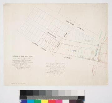
Block & Fort Hill Tract
Manuscripts
Castelar to Buena Vista St., Bellevue Ave. (Short St.) to Sand St., showing structures, lot owners, with notes; courses, distances, survey history. Paper watermark: Southworth’s 1882 Linen Bank. Alt title supplied by cataloger.
mssSolano SR_Map_0737

Partition Map of lots 14, 15, 16, 19 and 20 of the Childs Tract
Manuscripts
...showing division made by the owners; showing lot numbers, courses, distances Grand Avenue, waterways (red & black ink, pencil notations). Alt. title supplied by cataloger.
mssSolano SR_Box_27(14).07

Lots in the Fort Hill Tract
Manuscripts
Buena Vista to Philadelphia St. from Sand and Temple St. to Canal & Reservoir and Short St.; includes cemetery, F & A.M., I.O.O.F.; adjacent tracts: Bunker Hill, Pavilion. Alt title supplied by cataloger.
mssSolano SR_Map_0625

Map of the Eaton Lots on the N.W. side of New High Street
Manuscripts
New High to Buena Vista St., north from Temple St., showing structures, lot owners [no one named Eaton]. Red & black ink with color highlights; bearings & distances. Alt title supplied by cataloger.
mssSolano SR_Map_0448

Diagram from Grove and Wilkinsons Map of the City of Los Angeles
Manuscripts
South of Stevenson St. off Boyle Ave., showing courses, distances, acres, Lot 1, Orphan Asylum and other parcel owners; red highlights. Alt. title supplied by cataloger.
mssSolano SR_Box_29(36).03