Visual Materials
Southern Provinces of the United States
You might also be interested in
Image not available
Southern Provinces of the United States
Visual Materials
Kashnor notes, "Shows the country west of the Mississippi, with Kentucky as a state and Indiana as a territory to the north of Virginia, Ohio is shown, but with boundaries, and it locates New Salem, Chilcotha, Marietta, Dayton, Cuyahoga River and a territory so named." Vignette: Characteristic Scenery on the Hudson River.. Prime meridian: GM. Relief: hachures. Graphic Scale: Miles. Projection: Pseudocylindrical. Printing Process: Copper engraving. Other Features: Vignettes. Verso Text: MS note: 539.
093:539 M
Image not available
A New Map of Part of the United States of North America, exhibiting the Western Territory, Kentucky, Pennsylvania, Maryland, Virginia, &c. also, the Lakes Superior, Michigan, Huron, Ontario & Erie; with Upper and Lower Canada &c. From the Latest Authorities. By John Cary, Engraver. 1811
Visual Materials
Kashnor notes, : Shows the Indian Boundary Line by the Treaty under Gen. Wayne, 1795, and the chain of forts, Miami, Wayne, Recovery, Knox, Hamilton and Washington." Prime meridian: London. Relief: pictorial. Graphic Scale: Miles, leagues. Projection: Pseudocylindrical. Printing Process: Copper engraving. Verso Text: MS notes: 638 S18.
105:638 M
Image not available
Map of the United States of North America Drawn from a number of Critical Researches By A. Arrowsmith, Hydrographer to H.R.H. the Prince of Wales. No. 10 Soho Square
Visual Materials
Kashnor notes, "The finest map of the Western Territory at the time, and the detail regarding Ohio, Illinois, and Michigan Territory is of great value, and very accurate. Shows the old Indian boundaries of 1792, and the chain of forts from Fort Washington to Fort Wayne. Of all mapmakers Aaron Arrowsmith was the one who excelled as a geographer." See 105:627M for an earlier copy, 105:629M for a later version. Cartouche: Niagara Falls. . Prime meridian: GM. Relief: pictorial & hachures. Graphic Scale: Miles. Projection: Pseudocylindrical. Printing Process: Copper engraving. Other Features: Cartouche. Verso Text: IV V VI Vii MS note: Arrowsmith U.S.A. iv sheets 628.
105:628 M
Image not available
A New Map of Part of the United States of North America, containing those of New York, Vermont, New Hampshire, Massachusetts, Connecticut, Rhode Island, Pennsylvania, New Jersey, Delaware, Maryland and Virginia. From the Latest Authorities, by John Cary, Engraver. 1806
Visual Materials
Kashnor notes, "The Western Territory comprises the greater part of Ohio of the present day, Locating Marietta, Fort Lawrence, and the old Indian treaty line of 1795." Prime meridian: GM. Relief: pictorial. Graphic Scale: Miles, leagues. Projection: Pseudocylindrical. Printing Process: Copper engraving. Verso Text: MS notes; 627 53.
105:637 M
Image not available
North America and the West Indies;
Visual Materials
Kashnor notes, "An exceedingly rare map, shoWing the country West of the Mississippi, the boundaries of Virginia, North and South Carolina, reaching to that river. The inset map of the country locates Old Forts EdWard, William Henry, Frederic, St. John, and Chamilles to the St. LaWrence, and Albany, Schenectadi, Forts Hunter and OsWego to Lake Ontario." Kashnor dates as ca. 1764. Submaps and treaty articles. See 093:532 for another copy. "a NeWMap, Wherein the British Empire and its limits, according to the difinitive (sic) Treaty of Peace in 1763, are accurately described, and the Dominions possessed by the Spaniards, the French and other European States; the Whole compiled from the NeWSurveys and Authentic Memoirs that have hitherto appeared. " Cartouche With Natives. Submaps: Particular Map of Baffin and Hudson's Bay; Map of the Country betWeen Montreal, Albany and OsWego. Paper sale tag, June 7, 1927 With MS note: #669.. Prime meridian: London, Ferro. Relief: pictorial. Graphic Scale: Miles, Leagues. Projection: Pseudocylindrical. Printing Process: Copper engraving. Other Features: CartoucheSub-mapsFigures .
105:669 M
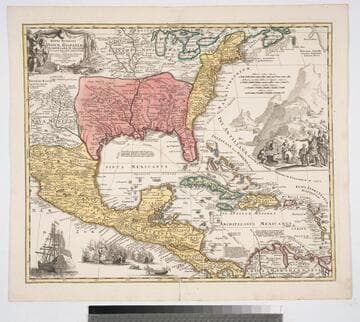
Regni Mexicani : seu Novae Hispaniae Ludovicianae, N. Angliae, Carolinae, Virginiae, et Pensylvaniae nec non insularum Archipelagi Mexicani in America Septentrionali accurata tabula exhibita / a Joh. Baptista Homanno
Visual Materials
Kashnor notes, "Gives a good map of New Mexico, locating Santa Fe and Taos; also shows the old boundaries of Louisiana." Kashnor dates as ca. 1730. Derived from L'Isle map. See 093:470M and RB 150049 for other copies. This copy seems earlier with better detailing. Vignettes: Sea battle; Merchants & Indians. Prime meridian: Ferro. Relief: pictorial. Graphic Scale: Miles. Projection: Pseudocylindrical. Printing Process: Copper engraving. Verso Text: MS note: 571.
105:571 M