Visual Materials
Caribee Islands and Guayana

You might also be interested in

Island of Hispaniola called by the French St. Domingo. Subject to France & Spain. from the best Authorities by Thomas Jefferys, Geographer to His Majesty
Visual Materials
RLIN record shows Jefferys as "geographer to his Royal Highness the Prince of Wales." Prime meridian: London, Ferro. Relief: pictorial. Graphic Scale: Miles, leagues. Projection: Cylindrical. Watermark: Crowned fleur-di-lis JWhatman. Printing Process: Copper engraving. Verso Text: MS note: 418.
105:418 S
Image not available
A Chart of the Harbour of Halifax, in Nova Scotia; with Jebucto Bay and Cape Sambro. also the Islands, Ledges of Rocks, Shoals & Soundings
Visual Materials
Kashnor notes, "The first issue of the Morris chart. It is the first separate chart of Halifax Harbour." The publication date is 1775 but Kashnor dates the map at [1760]. Includes sailing directions. Kershaw gives appeared in information and notes this is the second state of Jefferys' map. Detailed sailing directions.. "Survey'd by Order of His Excellency Brigadier General Lawrence, Governour of the Province of Nova Scotia; By Charles Morris, Chief Surveyor, Published by Command of the Rgiht Honourable the Lords of Trade & Plantations, For the Benefit of the Trade and Navigation of Great Britain and its Colonies." "To the Right Honourable George Dunk Earl of Halifax, First Lord Commissioner, and to the rest of the Right Honourable and Honourable Commissioners for Trade and Plantations, This Chart is most humbly Inscribed By their most obliged & obedient humble Sert. Thos. Jefferys." "London Engraved by Thomas Jefferys, Geographer to the King." Relief: hachures. Graphic Scale: Miles. Projection: Plane. Watermark: Crowned fluer-di-lis VI. Printing Process: Copper engraving. References: Kershaw 821. Verso Text: Ms note: 20.
105:660 M
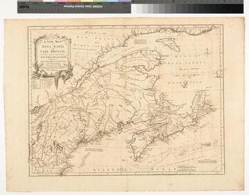
A New Map of Nova Scotia and Cape Britain. with the adjacent parts of New England and Canada, Composed from a great number of actual Surveys ; and other materials Regulated by many new Astronomical Observations of the Longitude as well as Latitude ; with an Explanation
Visual Materials
Kashnor notes, "The first issue of Jefferys' map. It was re-issued twenty years later by Sayer and Bennett." Kershaw states this is the second state of Jefferys map. Prime meridian: London, Ferro. Relief: pictorial. Graphic Scale: Miles, leagues. Projection: Pseudocylindrical. Watermark: I Ville Ary under IHS Crowned fleur-di-lis over LVC. Printing Process: Copper engraving. Other Features: Cartouche. References: Kershaw 739; McCorkle 755.20. Verso Text: MS note: 668.
105:668 M

St. Christophers, or St. Kitts, surveyed By Anthony Ravell Esqr. Surveyor General of the Islands of St. Christophers, Nevis, & Montserrat. Engraved by Thomas Jefferys Geographer to the King
Visual Materials
See 093:827M for an earlier copy. Vignette: Nevis from shipboard Submap: Nevis, by Thomas Jefferys.. Prime meridian: London, Ferro. Relief: hachures. Graphic Scale: Miles, leagues. Projection: Cylindrical. Printing Process: Copper engraving. Other Features: VignettesSub-maps. Verso Text: MS notes: 828.
093:828 M
Image not available
Amérique ou Indes Occidentales, avec les Nouvelles Découvertes du Capite. Cook, depuis le Détroit de Behrings ou du Nord, dans l'Océan Pacifique du Nord et Sud
Visual Materials
Kashnor notes, "Delamarche succeeded Vaugondy as a geographer. The map shows the correct coastline of California, and north-west to Alaska. Locates San Francisco and Columbia River." Table of state divisions per earlier Robert de Vaugondy map 093:164M. Table listing political subdivisions, right side.. Prime meridian: Paris, Ferro. Relief: pictorial. Graphic Scale: Miles, leagues. Projection: Pseudocylindrical. Printing Process: Copper engraving. Verso Text: MS note: 203.
105:203 M
Image not available
A Map of the Located Districts in the Province of Upper Canada, Describing all the New Settlements, Townships, &c., with the adjacent Frontiers, Compiled and Corrected from the Latest Surveys in the Surveyor General's Office
Visual Materials
Kashnor notes, "A very fine large scale map,fully detailed, giving the most accurate view of Upper Canada 113 years ago. Shows all the counties west of Lake St. Clair, locating Sandwich and Amherstburg; also York, Queenston, Forts Chippewan and Erie. Buffalo is called New Amsterdam." "by William Chewitt, Senior Surveyor & Draughtsman, Under the Direction of Francis Gore Esq., Lieutenant Governor &c. &c. To whom this map is most respectfully inscribed, By William Faden, Geographer to His Majesty, and His Royal Highness the Prince Regent. Charing Cross January 1st. 1813." "Cooper Sculp." Prime meridian: GM. Relief: no. Graphic Scale: Miles. Projection: Pseudocylindrical. Printing Process: Copper engraving. Verso Text: MS notes: 684 T5 Faden Map of Upper Canada 1813.
105:684 M