Visual Materials
A New Map of the West Indies, For the History of the British Colonies by Bryan Edwards, Esqr

You might also be interested in
West Indies
Visual Materials
Kashnor notes, "Engraving representing sugar being embarked." Kashnor dates as [1760]. Cartouche: Traders & slave MS note: 976 (on backing).. Prime meridian: London. Relief: pictorial. Graphic Scale: Miles. Projection: Conic. Printing Process: Copper engraving. Other Features: Cartouche.
105:976 S

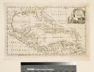
Compleat Map of the West Indies, Containing the Coasts of Florida, Louisiana, New Spain, and Terra Firma: with all the Islands. By Samuel Dunn, Mathematician
Visual Materials
Prime meridian: Ferro. Relief: pictorial. Graphic Scale: Miles, leagues. Projection: Conic. Watermark: Fleur-de-lis over GR. Printing Process: Copper engraving. Verso Text: MS notes: 716 West Indies 41.
093:716 M

West Indies
Rare Books
Previous folder suggests London and 1778?. "from the best Authorities, by T. Bowen, Geog." Prime meridian: London. Relief: pictorial. Graphic Scale: Miles. Projection: Conic. Printing Process: Copper engraving. Verso Text: MS note: 150228.
150228

A New and Accurate Map of East and West Florida, Drawn from the best Authorities
Visual Materials
some text transfer to map. MS note: 395 (on backing). Prime meridian: London. Relief: pictorial. Graphic Scale: Miles. Projection: Pseudocylindrical. Printing Process: Copper engraving.
105:395 S
Image not available
A New and Correct Map of the British Colonies in North America Comprehending Eastern Canada with the Province of Quebec, New Brunswick, Nova Scotia, and The Government of Newfoundland: with the Adjacent States of New England, Vermont, New York, Pennsylvania and New Jersey
Visual Materials
Lays out boundaries of French fishing rights and shows old boundary of French territory of Quebec. See 093:247M for another copy. Beaver surmounts cartouche.. Prime meridian: London. Relief: pictorial. Graphic Scale: Miles. Projection: Conic. Printing Process: Copper engraving. Other Features: Cartouche. References: Phillips 6016; McCorkle 790.12. Verso Text: MS note: 308.
105:308 M
![Map of the most Inhabited part of New England, containing the Provinces of Massachusets [sic] Bay and New Hampshire, with the Colonies of Conecticut [sic] and Rhode Island, Divided into Counties and Townships:](/_next/image?url=https%3A%2F%2Frail.huntington.org%2FIIIF3%2FImage%2F22APN4KVPPAA%2Ffull%2F%5E360%2C%2F0%2Fdefault.jpg&w=750&q=75)
Map of the most Inhabited part of New England, containing the Provinces of Massachusets [sic] Bay and New Hampshire, with the Colonies of Conecticut [sic] and Rhode Island, Divided into Counties and Townships:
Visual Materials
Maine is shown as the Eastern Part of Massachusets. This map derived from Thomas Jeffery's map of 1765. Prime meridian: Ferro. Relief: pictorial. Graphic Scale: Miles, leagues. Projection: Cylindrical. Watermark: Crowned fleur-di-lis JWhatman. Printing Process: Copper engraving. References: McCorkle 771.4.
105:108 M