Rare Books
The Kirkman - Harriman pictorial and historical map of Los Angeles County: 1860 A.D. 1937 A.D
You might also be interested in
Image not available
Map of the City of Long Beach Los Angeles County, California
Rare Books
Series of seven copies of the same map. Copy more info from OPAC. "Compiled from, official records and from other reliable data by C. I. Goucher, C.E." "American Eng. Co. L.A." MS notes and lines on each sheet.. Relief: no. Graphic Scale: Feet. Projection: Plane. Printing Process: Lithography. Verso Text: Map: Map if Southern Pacific Company's Roads in Southern California. Bird's Eye View of Long Beach Cal. Advertizing varies on each sheet..
150225

Map of the San Pasqual Plantation : also showing portion of Los Angeles County, California
Rare Books
Note included in folder with map states, "This map of the San Pasqual Plantation was enclosed in a letter which J. W. North wrote to his wife from Los Angeles, July 22, 1870. It was photostated by the County Surveyor's office of Los Angeles County in July of 1943. That office had a similar map of the 'H. G. Monk Tract' which was platted in 1883. Mary H. Shepard." The back of the note reveals her address as 469 Miles St., Pasadena 5. An MS note indicates a positive photo is in with the North letter in the MS. Dept., and a negative copy in the Photo Dept. Description for sales. MS note: 255611 MS additional property lines. Stamp for R. M. Widnet, Attorney at Law and Real Estate Agent, Los Angeles, Cal.. Relief: hachures. Projection: Plane. Printing Process: Lithography.
255611
Image not available
Map of Newhall Oil District showing the property of Pacific - Union Oil Co. in Los Angeles County California
Visual Materials
Old shelf number Eph J2d. A copy of the Newhall map, ephMPCALIF0136 with the title changed and a few added notes. According to phone books of the time, Newhall Oil & Development was in business from approxiately 1900 to 1911. Housed with RB ephMPCALIF0135 and ephMPCALIF0136. Prime meridian: GM. Relief: no. Graphic Scale: Chains. Projection: Cylindrical. Printing Process: Lithography. Verso Text: MS note: Eph J2d. .
ephMPCALIF0137
Image not available
Clason's map of the Los Angeles district
Visual Materials
Old shelf number ephJ2d. Cover for this map is an advert for Walk-Over Shoes. Within the cover is a small map of downtown. The main map shows public transportation routes by trains and street cars in great detail. Submap: Downtown Los Angeles (in cover). MS note: 1911. Prime meridian: GM. Relief: hachures. Graphic Scale: Miles. Projection: Cylindrical. Printing Process: Lithography. Verso Text: MS note: Eph J2d.
ephMPCALIF0047
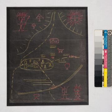
Indian map of Los Angeles before European settlement
Manuscripts
Verso: "Copy of Map loaned to Loomis" "45". Negative (11 3/4 x 9 3/4 in. with color added) & positive (13 x 10 1/2 in.) photostat copies. Verso of negative copy: "This is a exact copy of the Indian Map made me (tracing) before I lent the original to (Carlos) Loomis [signed] S.B. Reeve, C.E.". Supplied title is entirely conjectural.. Title supplied by cataloger.
mssSolano SR_Map_0274.03
Image not available
Map of portions of Los Angeles, San Bernardino and San Diego Counties, Southern California / R. Renshaw draftsman and engraver Los Angeles Cal
Rare Books
A map from San Fernando to San Diego prominently showing Lake Elsinore but also towns and ranchos, with railroads and wagon roads. Elsinore was founded in 1883, but map must also predate 1889, when Orange County was created. For another copy, see RB ephMPCALIF0027; for a later version of the map which focuses on Lakeland and Wildomar, see RB ephMPCALIF0061. MS note: 359324. Prime meridian: GM. Relief: hachures. Graphic Scale: Miles. Projection: Cylindrical. Printing Process: Lithography. Verso Text: MS note: 359324.
359324