Visual Materials
New Map of the Island of St. Christophers being an Actual Survey taken by Mr. Andrew Norwood, Surveyr. Genll. By John Thornton at the Sign of England Scotland & Ireland in the Minories London. ; New Map of the Island of Guardalupa. ; New Map of the Island of Martineca

You might also be interested in
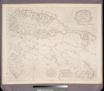
New Map of the Island of St. Christophers being an Actual Survey taken by Mr. Andrew Norwood, Surveyr. Genll. ; New Map of the Island of Guardalupa. ; New Map of the Island of Martineca
Visual Materials
A later copy of Thornton's map. Three maps on one sheet. Kashnor dates as ca. 1730. Relief: pictorial. Graphic Scale: Miles. Projection: Plane. Printing Process: Copper engraving. Verso Text: MS notes: 780.
105:780

New Chart of the Bahama Islands And the Windward Passage by John Thornton Hydrographer At the Signe of England, Scotland, and Ireland, in the Minories London
Visual Materials
Kashnor notes, "Shows also Cuba, Jam aica and part of Hispanola bordering on the Windward Passage." Kashnor dates as ca. 1680. Cartouche: minimal. MS note: 741 (on backing) . Relief: pictorial. Graphic Scale: Leagues. Projection: Cylindrical. Printing Process: Copper engraving. Other Features: Cartouche. Verso Text: MS note: 741 (on backing) .
093:741 M

Map of the English Empire in the Ocean of America or West Indies, revised by J. Senex; A New Map of the Island of Jamaica; Barbados & Bermuda; Tobago; Antego; St. Christophers; Harbour at Port Royall
Visual Materials
Kashnor notes," The map of Bermuda locates all the tribes." This map is eight maps on one sheet. See 105:192 for earlier version of this map. Eight maps on one sheet. MS notes: 10 Sen 0 Savanna, signifies a Plain . Relief: pictorial. Graphic Scale: varies. Projection: Plane. Printing Process: Copper engraving. Other Features: Sub-maps. Verso Text: MS note: 191.
105:191 M
Image not available
New Map of New England. New York. New Jarsey. Pensilvania. Maryland. and Virginia
Visual Materials
Kashnor notes, "Shows the coast from Boston Harbor to the Chesapeake. The inset map locates New York, Bergen, West Chester and Flushing, Brookland, Newtown, Flatbush, Bedford, Utrecht and Gravesend on Long Island; in New Jersey it locates Newark, Woodbridge and Elizabeth Towne. Perth Citty, Dockura and Middletown." Kashnor dates ca. 1680. McCorkle confirms this is first edition, 1680. Submap: New York Harbor Cartouche with putti.. Relief: pictorial. Graphic Scale: Miles. Projection: Cylindrical. Printing Process: Copper engraving. Other Features: Sub-mapsCartouche. References: McCorkle 680.4. Verso Text: MS note: 93 489.
093:489 M
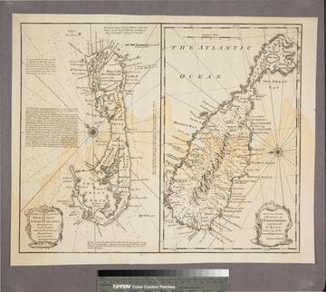
New & Accurate Map of Bermudas or Sommer's Islands, taken from an Actual Survey wherein the Errors of former Charts are corrected. Accurate map of the Island of St. Christopher, vulgarly called St. Kits, Containg all the Towns, Villages, Forts &c
Visual Materials
Two maps on one sheet. Kashnor dates as ca. 1730. RLIN record dates as 1752. Prime meridian: London. Relief: pictorial. Projection: Plane. Printing Process: Copper engraving. Verso Text: MS note: 190.
105:190 S
Image not available
Harbour of Casco Bay, and Islands Adjacent
Visual Materials
Kashnor notes, "Locates 'Casco Fort built by Col. Runamer', Fort George and the Irish New Settlemen, and Brunswick Town, near Kennebec River." Kashnor dates as ca. 1758 Relief: no. Graphic Scale: Miles. Projection: Plane. Printing Process: Copper engraving. Verso Text: MS note: 491.
105:491 M