Rare Books
Map of Coal River, in Kanawha & Boone Counties West Virginia
You might also be interested in
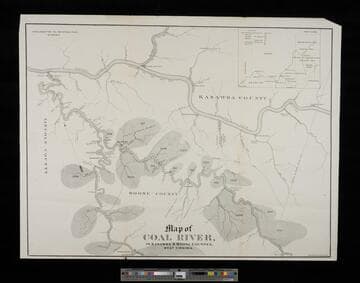
Map of Coal River, in Kanawha & Boone Counties, West Virginia
Visual Materials
No old shelf mark. The area south of Charleston. Submap: Wider area view from New York to Indiana. Prime meridian: GM. Relief: no. Projection: Cylindrical. Printing Process: Lithography.
ephMPWVA0003
Image not available
Title Map of the Coal Field of the Great Kanawha Valley, West Virginia, United States of America by John S. Swann, Attorney at Law, Charleston, Kanawha County W. Va
Rare Books
A map attempting to clarify the sometimes overlapping mining claims of the area surrounding Charleston, West Virginia. Drawn by an attorney and attested to by other attorneys. Submap: Map of West Virginia. Relief: no. Graphic Scale: Miles. Projection: Plane. Printing Process: Lithography. Other Features: Sub-maps. References: Phillips, Maps p. 302.
150220
Image not available
Map of coal land in the rich belt of the Kanawha Coalfield : compiled from the deed books of Kanawha County and maps of County Surveyors Sinnet, Matthews, Cole, Robson, Tyree, Styles and Slaughter, and from railroad surveys / by M.F. Maury
Visual Materials
No old shelf mark. Three creeks run into the Kanawha River on the map: Armstrong Crk., Paint Crk., and Cabin Crk. (Jerry West?) Nice view of Coalburg lower left. Vignette: View of the Kanawha Hills from Coalburg. Prime meridian: GM. Relief: no. Graphic Scale: Poles (assumed to be rods). Projection: Cylindrical. Printing Process: Lithography.
ephMPWVA0001
Image not available
Lewis Baker & Co.'s new railroad, county and district model map of West Virginia and the adjacent counties of adjoining states : showing every railroad station and post office in the territory included also the congressional and senatorial districts of the state, the area in square miles of each county, its population in 1880, its vote and its political complexion
Rare Books
Alternate title from cover. Lewis Baker & Co. are publishers of a newspaper in Wheeling, W. Va. Prime meridian: GM, Washington. Relief: hachures. Graphic Scale: Miles. Projection: Polyconic. Printing Process: Lithography.
82225