Visual Materials
North America Index Map to Canada and the United States, Published under the Superintendence of the Society for the Diffusion of Useful Knowledge
You might also be interested in
Image not available
North America Sheet XIII Parts of Louisisana, Arkansas, Mississippi, Alabama & Florida. Published under the Superintendence of the Society for the Diffusion of Useful Knowledge
Visual Materials
MS note: 435 (on backing). Prime meridian: London. Relief: no. Graphic Scale: Miles. Projection: Cylindrical. Printing Process: Copper engraving. Verso Text: MS note: 435 (on backing).
093:435 S
Image not available
Boston, with Charlestown and Roxbury. Under the Superintendence of the Society for the Diffusion of Useful Knowledge
Visual Materials
Kashnor notes, "Shows all the bridges, and the dates they were built, and the railways. A scarce map." MS note: 453 (on backing). Relief: hachures. Graphic Scale: Miles, yards. Projection: Plane. Printing Process: Engraving. Verso Text: MS note: 453 (on backing).
093:453 S

British Islands in the West Indies Published under the Superintendence of the Society for the Diffusion of Useful Knowledge
Visual Materials
Fifteen islands and island groups on one sheet. Submaps: Virgin Islands; Grenadines; Grenada; Trinidad; Jamaica; New Providence; Anguila; Grand Cayman; Roatan; Leeward Islands (St. Christopher, Barbuda, Antigua); St. Lucie; Dominica; St. Vincent; Tobago; Barbadoes. MS note: 708 (on backing). Relief: hachures. Projection: Plane. Printing Process: Engraving. Other Features: Sub-maps.
093:708 M
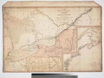
Map exhibiting the Frontiers of Canada and the United States, intended to illustrate The Operation of the British & American Armies
Visual Materials
Kashnor notes, "A scarce map issued during the War of 1812." Submap of East Coast from St. Lawrence River to Chesapeake Bay. Submap: Sketch of the Coast of North America from the River St. Lawrence, to Chesapeake Bay. MS notes at top give positions of British and "Enemy" forces on 30th Oct (year uncertain).. Prime meridian: GM. Relief: no. Graphic Scale: Miles. Projection: Azimuthal. Printing Process: Engraving. Other Features: Sub-maps. Verso Text: CANADA.
093:245 M
Image not available
British North America
Visual Materials
Kashnor notes, "Shows the boundary of Oregon reaching in a semicircle from Juan de Fuca Strait to include the northern part of the Columbia River, and as part of the United States." "Engraved by J. & C. Walker." "Hudson Bay Comps. M.S.S. Parry, Franklin, Beechey, Graab, &ce." See RB 71145 for another copy. Prime meridian: GM. Relief: hachures. Graphic Scale: Miles. Projection: Azimuthal. Printing Process: Lithography. Verso Text: MS notes: 696 30.
105:696 S