Rare Books
Map of the Mississippi and Ohio Valleys : showing Chain of Historic French Forts
You might also be interested in
Image not available
Map of Canada : showing Historic Forts and Trading Posts
Rare Books
A blueline map with forts designated by number but no key to the meaning of the numbers. Key is probably in the Departments publication cited above. "Department of the Interior Hon. Thomas G. Murphy, Minister W. W. Cory, Deputy Minister." Prime meridian: GM. Relief: no. Graphic Scale: Miles. Projection: Cylindrical. Printing Process: Blueline print. Verso Text: MS note: 183607.
183607
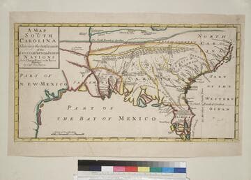
A Map of South Carolina : Shewing the Settlements of the English, French, & Indian Nations from CharlesTown to the River Mississippi
Rare Books
Kashnor notes, [Quotes first from Nairne (note spelling) in a letter to Charles Spencer, third Earl of Sutherland explaining he drew the map accurately from personal observations.] "There can be no question but that the map was engraved in a very limited issue for the use of the Government. We only know of one other copy, and apparently there is no record of the map or of Nairne. The details are engraved in this form, 'Chicasa, 600 men, Chactas, 700 men.... For such a map there is an enormous amount of information and the greatest authenticity. Nairne was a member of the House of Commons of South Carolina." [Three forts on the S. Carolina coast inked in.] Kashnor also notes,[No imprint but London, 1709-10] "By Capt. Tho. Nairn." Prime meridian: Charleston,SC. Relief: pictorial. Graphic Scale: Miles. Projection: Cylindrical. Printing Process: Copper engraving.
152679
Image not available
Map showing lots in the Fort Hill Tract proposed to be sold by the City of Los Angeles Aug 27th, 1885
Rare Books
Attached is a copy of Ordinance No. 206 approving this sale, and signed by W. W. Robinson, then Clerk of the Council of the City of Los Angeles, dated December 15th, 1885. Part of this property is now the 101 Freeway while another portion is the site of the Los Angeles Archdiocese Cathedral. Cemetery Ave became Hill Street. MS calculations lower right. Ordinance pasted to map upper left.. "Renshaw Engr. Downey Block, L.A." Relief: no. Graphic Scale: Feet. Projection: Plane. Printing Process: Lithography. Verso Text: MS note: 150287.
150287
Image not available
Colton's Map of the Southern States. Including Maryland, Delaware, Virginia, Kentucky, Tennessee, Missouri, North Carolina, South Carolina, Georgia, Alabama, Mississippi, Arkansas, Louisiana, Texas. Showing also parts of adjoining States & Territories locating the Forts and Military Stations of the U. States & showing all the Rail Roads, R. R. Stations & other internal improvements. Published by J. H. Colton 172 William Street, New York 1862
Visual Materials
Submaps of Florida and the entire United States with proposed Railroad routes to the west coast. This map was resold by a London map dealer, see verso information. Attached to this map is a copy of "Seat of War in the Americas," see 105:368M for another copy. See 093:364, Accession no. 130475, for another copy on linen in folder. Submaps: Southern part of Florida; Colton's map of the United States showing the proposed Railroad Routes to the Pacific Ocean. Table: Census data by states for 1860. Attached map of the Seat of the War in America, see 105:368M. Leaf and grape border. Numerous ships along the coastlines.. Prime meridian: Washington. Relief: hachures. Graphic Scale: Miles. Projection: Pseudocylindrical. Printing Process: Lithography. Other Features: Sub-mapsBorder. Verso Text: Map Title same as on map face, but printed in red. Label pasted over bottom portion: London: Bacon & Co., 48 Paternoster Row. [London agent for Colton] Advertisement for other Colton maps handled by Bacon & Co. also pasted to verso..
093:425 M