Rare Books
Chapman's Sectional Map of Wisconsin, with the most recent surveys
You might also be interested in
Image not available
Map of Baltimore
Rare Books
Street and public area directory in the surround. "Entered according to the Act of Congress, in the year 1867, by John W. Woods, in the Clerk's Office of the District Court of Maryland." "Lith. by A. Hoen & Co. Second St. Balto." Prime meridian: GM. Relief: no. Projection: Plane. Printing Process: Lithography. Verso Text: MS note: 127979.
127979

De Groot's map of the Washoe Mines
Rare Books
At head of title: 3rd. Edition. "D. Wiel" "L. Nagel Lith." "Entered according to Act of Congress in the year 1860 by Hutchings & Rosenfield in the Clerk's Office of the District Court of the Northern District of California." Title on cover: Map of Washoe. Prime meridian: GM. Relief: hachures. Graphic Scale: Miles. Projection: Cylindrical. Printing Process: Lithography.
1955
Image not available
Chapman's Sectional Map of the State of Iowa : Compiled from the United states surveys and other authentic sources
Rare Books
Alt. title from cover. Prime meridian: GM. Relief: no. Graphic Scale: Sections. Projection: Cylindrical. Printing Process: Lithography.
312871
Image not available
Map of the City and County of San Francisco : carefully compiled from recent surveys, including all the new additions of Cities, Towns, and Villas delineating the lines of Ranchos, Private Claims, Water Works, Railroads, &c &c
Rare Books
"Lith Britton & Rey S.F. Entered According to Act of Congress in the year 1863 by Frederick Marriott in the Clerks Office of the U.S. District Court of Northern California." Prime meridian: GM. Relief: no. Graphic Scale: Miles. Projection: Plane. Printing Process: Lithography.
2206
Image not available
Map of Lower Oregon and Upper California from the latest and most authentic surveys
Rare Books
From the Umpqua River on the north to Cape Mendocino and Red Bluff on the south. Shows the various trails through the area and the site of "One Horse Town." Also the Yreka canal is shown. "Entered according to Act of Congress in the Year 1853 by Thomas Tennent in the Clerks Office of the District Court of the United States for the Northern District of the State of California." "Lith. by Alex Zakreski Cor. Washington & Monty." MS note: 132849. Prime meridian: GM. Relief: hachures. Projection: Cylindrical. Printing Process: Lithography. Verso Text: MS note: Davis In "Columbia" Aug '67.
132849
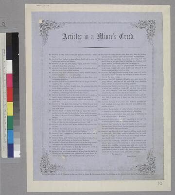
Articles in a Miner’s Creed
Rare Books
Image of a list of articles that comprise various beliefs of a miner. It is signed "Forty-Nine" and is surrounded by a border with flowers in each corner. "Entered according to Act of Congress in the year 1855, by James M. Hutchings, in the Clerk's Office of the District Court for the Northern District of Cal."--text, below image. Paper color: blue.
48052:010