Rare Books
Plano del segundo piso y la Iglesia principal del Convento grande y Casa Capitular de N.S.P.S. Francisco de la cuidad de Santiago de Querétaro. Octobre 19 de 1858
You might also be interested in

Plano de la ciudad de Cordoba / levantado y dibujado par le ingeniero Albano M. de Laberge
Rare Books
Kirkpatrick Catalogue entry: "2467 d Laberge, A. M. Plano de la ciudad de Cordoba. Paris, Imp. Destouches, 1860. 1 sheet. [see p.]."Numerous indecipherable notes in Burton's hand. Probably obtained while Burton was in South America between 1865 and 1868. Vignette: Vista Tomada desde el alto del Pucara Novembre 1860. MS note: El Lueco, many more in Burton's hand.. Prime meridian: Paris. Relief: hachures. Graphic Scale: Varas (1000 varas shown as 3.25"). Projection: Plane. Printing Process: Lithography. Other Features: Vignettes. Verso Text: MS notes: Cordona R.B. 11491. r. p maps Americas Lebarge 2467. Stamp: Kensington Public Libraries..
623642
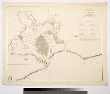
Plano del Puerto Cuidad ed la Havana levantado por D. José Del Rio Capitan de Fragata de la Rl. Armada. Ano de 1798
Visual Materials
Marked from Depositi Hidrographico [Spain] Relief: hachures. Graphic Scale: Miles. Projection: Plane. Watermark: SERRA. Printing Process: Copper engraving. Verso Text: MS note: 753.
093:753 M
Image not available
Plano de la Plaza de la Colonia del Sacramento
Visual Materials
Kashnor notes, "An exceedingly rare map of this colony, established about 10 leagues from Buenos Ayres." Submap: Parte de la Costa Septentrional del Rio de la Plata.. "Situada sobre la Costa Septentrional del Rio de la Plata. Demuestrase las Baterias, y ataques, que la pusieron los Espanoles el dia 1st Octobre del Ano de 1762, mandados por el Exmc. S. D. Pedro Cevallos, a quines se rindio a fines de dtho. mes y Ano. Por D. Tomas Lopez, Madrid, Ano de 1777." "Se hallara este con todes las Obras del Autor, en Madrid, en la Cale de las Carretas." Relief: hachures. Graphic Scale: varas, toesas. Projection: Plane. Watermark: BRVMEV. Printing Process: Copper engraving. Other Features: Sub-maps. Verso Text: MS note: 867.
105:867 M

Plano topografico de los alrededores de Buenos Ayres levantado con licencia del Superior Gobierno / por Dn. Adolfo Sourdeaux Ex Capitan. Ayudante de Campo del Inspector Genal. de Infanteria de Marina Francesca
Rare Books
Kirkpatrick Catalogue entry: "2479 d l Sourdeaux, A. Plano topografico de los alrededores de Buenos Ayres levantado con licenia del Superior Gobierno. [Buenos Aires], Liberia de la Victoria, [c. 186-]. 1 sheet. [see cabinet]." This map used to lay out a water system for the town. Numerous MS notes to the right of the map describing towns and sites, notes on the map performing calculations. Probably obtained while Burton was in South America between 1865 and 1868. Cartouche: Figures. MS notes: many notes and calculations for water system. 2479 -tom (map cabinet). . Prime meridian: GM. Relief: no. Graphic Scale: varas. Projection: Cylindrical. Printing Process: Lithography. Other Features: Cartouche.
623653

Carte de la Confédération Argentine divisée en ses différentes provinces et territoires, et de pays voisins: état oriental de l'Uruguay, Paraguay partie du Brésil et de la Bolivie, Chili / par le Dr. V. Martin de Moussy. 1867
Rare Books
Kirkpatrick Catalogue entry: "2472 l Moussy, V. M. de. Carte de la Confédération Argentine ... et de pays voisins, État oriental de l'Uruguay, Paraquay, partie du Brésil et da la Bolivie. Paris, Imp. Lemercier, 1867. 1 sheet. [see p.]." MS notes at bottom of sheet, the one on the right reads "Sr. Presidente Mitre." Probably obtained while Burton was in South America between 1865 and 1868. MS notes: bottom margin names. RB 11492 t Stamp: Kensington Pu8blic Libraries.. Prime meridian: Paris. Relief: hachures. Graphic Scale: Milesm leagues. Projection: Polyconic. Printing Process: Lithography. Verso Text: MS notes: Argentine Confederation 2472 p maps Moussy. Sticker R.B. 11492 t..
623646
Image not available
Nuevo mapa de los estados de Sonora, Chihuahua, Sinalao, Durango y territorio de la Baja California / formado por E. de Fleury ex oficial de plana mayor en el Ejercito Frances, ex coronel de Artilleria e' ingeniero en gefe del Estdo. de Sonora (Mexico)
Rare Books
Description of roads and trails throughout region. Prime meridian: GM. Relief: hachures. Graphic Scale: Miles. Projection: Cylindrical. Printing Process: Lithography. Verso Text: Fornia Part of Mexico 4.
477766