Rare Books
Magna Britannia et Hibernia Secundum Kitchen et Dorret recens descripta et edita / a Joanne Walchio, Aug. Vind
You might also be interested in
Image not available
Europa : secundum recentissimas clarissimorum Geographorum observationes exhibita / prostat apud Joannem Walch, Augustiae Vindelicorum
Rare Books
Submap: Azores. Prime meridian: Ferro. Relief: pictorial. Graphic Scale: Miles. Projection: Conic. Watermark: SC. Printing Process: Copper engraving.
279158
Image not available
Septem Provinciae seu Belgium Foederatum, quod generaliter audit Hollandia : secundum recentissimas observationes / Prostat Augustae Vindelicorum apud Joannem Walch. MDCCLXXXXIV
Rare Books
Prime meridian: Ferro. Relief: pictorial. Graphic Scale: Leagues. Projection: Conic. Watermark: SC. Printing Process: Copper engraving.
279159
Image not available
La Prouincia di Treviso. Ager Tarvisinus. Le Province de Trevise
Rare Books
Prime meridian: Ferro. Relief: pictorial. Graphic Scale: Miles. Projection: Cylindrical. Watermark: Crescents, crowned W, AL. Printing Process: Copper engraving. Map title given in Italian, Latin, and French. Informational cartouche in Latin. Place-names in Italian.
216074
Image not available
Pensylvania Nova Jersey et Nova York cum regionibus ad fluvium Delaware in America sitis, nova delineatione ob oculos posita / per Tob. Conr. Lotter Geographum
Visual Materials
Creative cartography. Boston and Cape Cod are shown in Connecticut, New York and Pennsylvania are truncated. Kashnor dates as ca. 1760. Title and key in Latin, majority of geographical descriptions in German. For earlier map ascribed to Seutter, see RB 150204; for similar map see RB 111323. Cartouche: elaborate with Indians and animals. Prime meridian: Ferro. Relief: pictorial. Graphic Scale: Miles. Projection: Cylindrical. Printing Process: Copper engraving. Verso Text: MS note: 571.
093:571 M
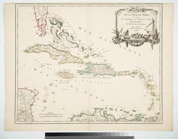
Partie de la Mer du Nord, ou se trouvent les Grandes et Petites Isles Antilles, et les Isles Lucayes
Visual Materials
Cartouche: Ships & shells.. "Guill. Delahaye Sculpsit." Prime meridian: Ferro. Relief: pictorial. Graphic Scale: Leagues, miles. Projection: Cylindrical. Watermark: Chained maltese cross lettering. Printing Process: Copper engraving. Other Features: Cartouche. Verso Text: MS notes: 969 Islers Antilles 107.
105:969 M
Image not available
Irlanda
Rare Books
Cartouche: Woman with lyre and spear, ships.. Prime meridian: Ferro. Relief: pictorial. Graphic Scale: Miles, leagues. Projection: Cylindrical. Watermark: Crescents plus. Printing Process: Copper engraving. Other Features: Cartouche.
216072