Visual Materials
A map of the new governments, of east & west Florida

You might also be interested in
Image not available
New Map of Canada, Also the North Parts of New England and New York; with Nova Scotia and Newfound Land. From the Sr. Robert with Improvements
Visual Materials
Kashnor dates as ca. 1760. Submap of the Great Lakes. [Shows south limits of Canada including everything north of the 41st parallel west of Michigan.] See 105:671 for an earlier version of this map. McCorkle gives appeared in information. Submap: Supplement for the Lakes of Canada. MS note: 303 (on backing). Prime meridian: London. Relief: pictorial. Graphic Scale: Miles, leagues. Projection: Pseudocylindrical. Printing Process: Copper engraving. Other Features: Sub-maps. References: Kershaw 370; McCorkle 759.3. Verso Text: MS note: 303 (on backing).
093:303 S
Image not available
New Map of the North-East Coast of Asia and North-West Coast of America, with the late Russian Discoveries
Visual Materials
Kashnor notes, "ca. 1770." This map appears to be a reduced size English copy of Gerhard Müller's map. Minimal cartouche.. Prime meridian: Ferro & London. Relief: pictorial. Graphic Scale: No. Projection: Pseudocylindrical. Printing Process: Copper engraving. Other Features: Cartouche.
093:046 S
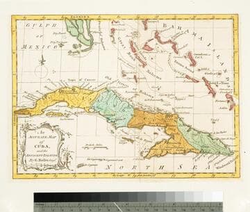
Accurate Map of Cuba, and the Adjacent Islands; by G. Rollos, Geogr
Visual Materials
Kashnor dates as ca. 1760. MS note: 748 (on backing). Prime meridian: London. Relief: pictorial. Projection: Pseudocylindrical. Printing Process: Copper engraving. Verso Text: MS note: 748 (on backing).
093:748 S

An Accurate Map of the West Indies, from the Latest Improvements
Visual Materials
Kashnor notes, "Shows the eastern coast from Cape Carteret to the mouth of the Orinoco, and locates New Leon in the position of present-day Texas." Kashnor dates as ca. 1760. MS note: 794 (on backing). Prime meridian: London. Relief: no. Projection: Pseudocylindrical. Printing Process: Copper engraving.
105:794 S
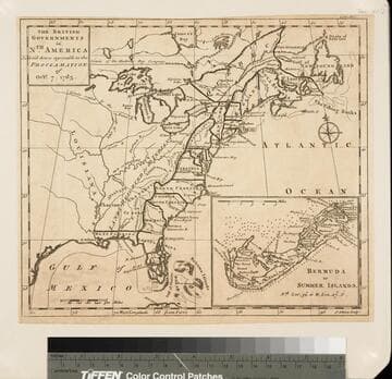
The British Governments in Nth. America Laid down agreeable to the Proclamation of Octr. 7, 1763
Visual Materials
Kashnor notes, "Giving the whole of N. America from James's Bay to Florida, and west to Louisiana." Inset map of Bermuda. Submap of Bermuda or Summer Islands. MS note: 131 Dec. 1763(p.577) (on backing). Prime meridian: Ferro. Relief: pictorial. Projection: Pseudocylindrical. Printing Process: Copper engraving. Other Features: Sub-maps. Verso Text: Ms note: 131 (on backing).
093:131 S

New Map of the British Empire in North America, Drawn from the latest Authorities
Visual Materials
Kashnor notes, "Showing the coast south to Florida, and the territories north-west of Lake of the Woods and Louisiana. A scarce map issued during the Revolution." On distinctive blue-gray paper often used by Kitchin. Millar's Geography was rushed to print in 1775 at start of American Revolution. Tip of Florida shown in submap. Cartouche shows natives bowing to Britannia.. Prime meridian: London. Relief: pictorial. Graphic Scale: Miles. Projection: Pseudocylindrical. Printing Process: Copper engraving. Other Features: Sub-mapsCartouche. References: McCorkel 782.10. Verso Text: MS note: 116.
105:116 S