Rare Books
The Isthmus of Panama between Porto Velo, Chagres & Panama / by J.A. Lloyd F.R.S

You might also be interested in
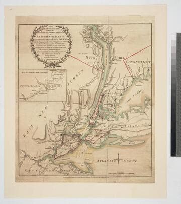
The seat of action between the British and American forces or an authentic plan of the western part of Long Island with the engagement of the 27th. August 1776. between the King's Forces and the Americans: containing also Staten Island, and the environs of Amboy and New York, with the course of Hudsons River, from Courtland the Great Magazine of the American Army, to Sand Hook / from the surveys of Major Holland
Visual Materials
Kashnor notes, "A rare war map." Ms note: 110 (on backing). Submap shows road from Amboy to Philadelphia. Relief: hachures. Graphic Scale: Miles, British. Projection: Plane. Watermark: I V. Printing Process: Copper engraving.
093:110 M
Image not available
Map of the City of Monrovia Los Angeles Co., Cal
Rare Books
Shows existing an proposed rail lines. MS notes: Rail lines in color, current major street names in margin. Submap: Southern California. Stamp: C. E. Slosson, Dea,ler in Real Estate, Monrovia, Cal. "Compiled from records and surveys by H. C. Miller, City Engineer February 1904." Relief: hachures. Graphic Scale: Feet. Projection: Plane. Printing Process: Lithography. Verso Text: MS note: 150264.
150264
Image not available
California map showing San Francisco, Newport and rail road connections with the adjacent country / drawn by W. Alpheus Smith. T.R. Holland Lith. Boston
Rare Books
Alternate title from bottom of page. Newport was to be located across Suisun Bay from New York (now called Pittsburg) and Antioch. A submap shows the street layout for the city and impressive rail connections to the north and east are shown on the main map. Bancroft characterized this as a "swindling project." Submap: Plan of Newport, California. MS note 442574. Descriptive notes in folder. Prime meridian: GM. Relief: hachures. Projection: Plane. Printing Process: Lithography. Verso Text: MS note: 442574.
442574