Rare Books
A map of the United States of Mexico : as organized and defined by the several acts of the congress of that republic constructed from a great variety of printed and manuscript documents / by H.S. Tanner
You might also be interested in

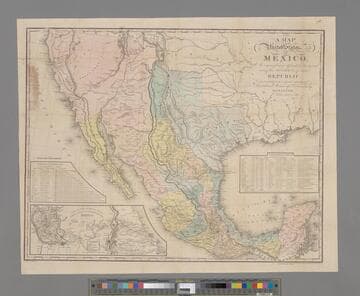
A map of the United States of Mexico : as organized and defined by the several Acts of the Congress of that Republic ; constructed from a great variety of printed and manuscript documents / by H.S. Tanner
Rare Books
For the fourth edition of this map, see RB 82223. A statistical table gives information about the various states including Upper California. Submap: Map of the Roads &c. from Vera Cruz & Alvarado to Mexico. Prime meridian: Washington. Relief: hachures. Graphic Scale: Miles. Projection: Azimuthal. Printing Process: Engraving.
43180

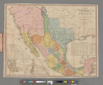
A Map of the United States of Mexico : As organized and defined by the several Acts of the Congress of that Republic
Rare Books
California is grossly distorted. With 2 inset Tables, and: "Map of the roads & from Vera Cruz & Alvarado to Mexico." Inside cover has MS notes: Seth B. Thornton, Capt. 2nd U.S. Dragoons, Monterey, Mexico, Sept 25th, 1846. A hard fight but we have then [?] Stronghold, to the brave lead regiment in [?]. Another hand: AH. Pitkin July 26, 83. "Entered according to Act of Congress, 2nd day of April, 1832, by H. S. Tanner of the State of Pennsylvania." "Constructed from a great variety of printed and manuscript documents by H. S. Tanner." Lettered on cover: Tanner's travelling map of Mexico. Prime meridian: Washington. Relief: hachures. Graphic Scale: Miles. Projection: Polyconic. Printing Process: Lithography.
1946
Image not available
Illinois and Missouri / by H.S. Tanner
Rare Books
Alternate title from cover. Canals and proposed rail lines shown in MS lines. MS notes on what was previously Putnam County show its division into Putnam, Bureau, Stark, and Marshall Counties; this change occurred in 1839. Details are most full near waterways, especially the Mississippi, Missouri, and Illinois Rivers. Very little detail around Chicago. Prime meridian: GM. Relief: hachures. Graphic Scale: Miles. Projection: Polyconic. Printing Process: Lithography. MS inside cover: Andrew Johnston, Quincy Illinois.
82219
Image not available
Map of the United States, British & Central America : from state documents & unpublished materials / by Professor H.D. Rogers of Boston U.S. and A. Keith Johnston, F.R.S.E. Geographer to the Queen
Rare Books
Alternate title from cover. The western section of this map is particularly interesting because of the lack of North and South Dakota, Montana and Idaho, Colorado, Nevada and Arizona and the consequent stretching of other states and territories. Insets: Montreal -- Quebec and its environs -- New York and its environs -- Boston and its environs -- Cincinnati & vicinity -- Philadelphia & vicinity -- New Orleans -- Continuation of Central America on the same scale -- San Francisco. Presented to the Huntington Library by Mr. & Mrs. Francis M. Wheat in memory of Carl I. Wheat, October 1975. Submaps: Central America; San Francisco; New Orleans; Louisville & Jeffersonville; New York; Boston; Cincinnati; Philadelphia; Montreal; Quebec. Prime meridian: GM. Relief: hachures. Graphic Scale: Miles. Projection: Polyconic. Printing Process: Lithography.
442556
Image not available
Map of the United States, including separate maps of California, Oregon, New Mexico, Nebraska, &c., with the Population of the several States, Railroads, Canals, &c. by H. S. Tanner. No. 201 Broadway, New York 1853
Visual Materials
Kashnor notes, "The map of California also shows Utah, which is called Deseret, and New Mexico, the Oregon map also shows Nebraska, which takes all the country to the Rockies from Fort Mandan." Inset city and state maps, statistical data of states to 1840. Cartouche w. oak tree and deer. Submaps: New Orleans, Charleston, Cincinnati, Environs of Baltimore and Washington, Environs of Philadelphia and Trenton, Environs of New York, Environs of Boston, Environs of Albany, Oregon and Nebraska, California, Pittsburg, Profile of the Grand Portage, Boston, New York, Philadelphia, Baltimore, Washington, South part of Florida. Statistics of the United States: States &c., Area, Capitol, Metropolis, Date of Constitn., Stated meetg. of legislature, Day of Genl. Election, Census data of 1790, 1800, 1810, 1820, 1830, 1840. . Prime meridian: Washington, DC. Relief: hachures. Graphic Scale: Miles. Projection: Azimuthal. Printing Process: Copper engraving. Other Features: CartoucheSub-maps.
093:176 M