Visual Materials
A map of Philadelphia and parts adjacent / by N. Scull and G. Heap
You might also be interested in
Image not available
A map of Philadelphia and parts adjacent / by N. Scull and G. Heap
Visual Materials
Kashnor dates as c.1777. Jolly places in Gent-87, August 1753. Accompanying note from WOW 2-18-32 - "Probably from Gentleman's Magazine, Aug. 1753. (Phillips, Descr. List of Maps of Phila. 1926. no. 150a) 2 separate issues." Variant of 093:573 per folder. MS note: 728 Mus. Cat. 105. 1777 (lower right). Relief: no. Projection: Plane. Printing Process: Copper engraving.
105:728 S
Image not available
A map of the country round Philadelphia : including part of New Jersey New York Staten Island & Long Island
Visual Materials
Kashnor dates as ca. 1760. Jolly identifies as from Gentleman's Magazine, of Sept. 1776 [as does printing transfer on verso]. MS note: 729 (on backing). Prime meridian: London. Relief: pictorial. Graphic Scale: Miles. Projection: Cylindrical. Printing Process: Copper engraving. References: Jolly, Brit. Periodicals Gent-247. Verso Text: Text transfer.
105:729 S

A chart of Delaware Bay and River : from the original by Mr. Fisher of Philadelphia 1776
Visual Materials
Kashnor notes, "Shows the river from Cape James to Philadelphia." From an original map drawn by Joshua Fisher in 1776 and later reprinted in the Gentleman's Magazine July 1779 (see RLIN NYPGR4442650-M). Oriented with north to the right. MS note: 91 (on backing) Note calling attention to verso note. Relief: no. Graphic Scale: Miles, English & Nautical. Projection: Plane. Printing Process: Copper engraving. Verso Text: MS note (hidden) Gent. Mag. July 1779. 91.
093:091 S
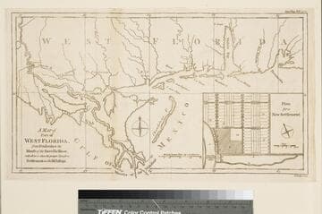
A Map of Part of West Florida, from Pensacola to the Mouth of the Iberville River, with a view to show the proper Spot for a Settlement on the Mississippi
Visual Materials
Submap: Plan for a New Settlement. MS note: 394 (on backing). Prime meridian: London. Relief: no. Graphic Scale: Miles. Projection: Cylindrical. Printing Process: Copper engraving. Other Features: Sub-maps. References: Jolly, Gent. 217.
105:394 S
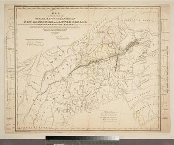
Map of that portion of Her Majestys Colonies of New Brunswick and Lower Canada the Title to which is disputed by the Government of the U. States with parts of the adjacent country
Visual Materials
Kashnor notes, " A scarce map on the North-Eastern boundary question." Sections of the terrain along the northeast line, Maine & Quebec, and the north-south line dividing Maine from New Brunswick at the sides of the map. MS note: 141 (on backing) Two section maps at sides of main map.. Prime meridian: GM. Relief: hachures. Projection: Mercator. Printing Process: Copper engraving. Other Features: Sub-maps.
093:141 S
Image not available
The Asiatic Part of the Russian Empire, from the maps published by the Imperial Academy of St. Petersburg with the new discoveries of Captn. Cook &c
Visual Materials
Kashnor notes, "Gives a good coastline of Kamtschatka and the Islands." Explanation of Russian and Chinese terms used. Scale in miles and wersts. Track of Pilot Petuszkoff, 1777-78. Also issued jointly with "The European part of the Russian Empire" See map 093:020 for this map joined to European Part of Russian Empire. Simple cartouche and detailing around scale; map extends beyond neatline showing Behring Straits and some Alaskan islands.. Prime meridian: Ferro. Relief: pictorial. Graphic Scale: Miles and wersts. Projection: Pseudocylindrical. Printing Process: Copper engraving. Other Features: Cartouche. Verso Text: MS note: No. 6.
093:006 M