Rare Books
Afrika Nordwestl. Blatt Afrika Nordöstl. Blatt

You might also be interested in

Afrika, südliches Blatt
Rare Books
Kirkpatrick Catalogue entry: "2452 d [Ravenstein, E. G.] Afrika, südliches Blatt. Hildburghausen, Verlag des Bibliographischen Instituts, 1862. 1 sheet. [see p.]."MS notes at top center of map. MS notes in upper part of map.. Prime meridian: GM. Relief: hachures. Graphic Scale: Miles, leagues. Projection: Polyconic. Printing Process: Lithography. Verso Text: Label; Map of South Africa..
623626

Dr. W. Junker's Reisen in Nordost- U. Cental-Afrika, Blatt No. 2. Karte der Routen in den Mudiríen. Rohl u. Bahr-el-Ghasál, sowie Übersicht der wichtigsten neueren Reisen in den Ägyptischen Äquatorialprovinzen / entworfen u. gezeichnet von B. Hassenstein
Rare Books
Kirkpatrick Catalogue entry: "2441 Hassenstein, B. Dr. W. Junker's Reisen in Nordost-u. Central-Afrika. Blatt No. 2: Karte der Routen in den Mudiríen. Rohl u. Bahr-el-Ghasál, sowie Ubersicht der wichtigsten neueren Reisen in den Ägyptischen Äquatorialprovinzen. Gotha, Justus Perthes, 1880. 1 sheet. From Petermann's geographische Mitteilungen, Jahrgang 1880, Tafel 4. [see cabinet]." MS notes: 2441 maps Africa Hassenstein. confirmed from the maps of Gabon. others.. Prime meridian: GM. Relief: hachures. Graphic Scale: Kilometers. Projection: Cylindrical. Printing Process: Lithography. Verso Text: Stamp: Kensington Public Libraries..
623615
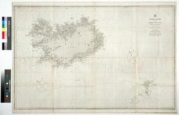
Iceland and the Færoe Islands : from the Danish survey
Rare Books
Kirkpatrick Catalogue entry: "2512 l ; [Great Britain. Admiralty.] Iceland and the Faeroe islands from the Danish survey 1845 corrected to 1866 ... London, Admiralty, [1872]. 1 sheet. [see p.]. Another copy."At head of title: "Hydrographic Office." Two copies.This copy with the linen backing, no MS notes. Prime meridian: GM. Relief: hachures. Projection: Mercator. Printing Process: Lithography.
623686a
Image not available
Map of the Province of Upper Canada, describing all the New Settlements, Townships &c., with the Countries Adjacent from Quebec to Lake Huron. Compiled from the Original Documents in the Surveyor General's Office
Visual Materials
Backed with linen and including a catalog of Wyld's publications on the verso. See also 105:687 for another copy without linen backing. Prime meridian: London. Relief: no. Graphic Scale: Miles. Projection: Pseudocylindrical. Printing Process: Lithography. Verso Text: MS note: 346 One section of 21 contains a complete catalog of Wyld's maps and atlases for sale at the time..
093:346 M

Südliches Wolta-Gebiet auf der Goldküste von West-Afrika nach den Angaben der Missionaire Locher & Plessing
Rare Books
Kirkpatrick Catalogue entry: "2440 Gross, R. Südliches Wolta-Gebiet auf der Goldküste von West-Afrika, nach den Angaben der Missionare Locher & Plessing. [n.p.], Rudolf Gross, [after 1855]. 1 sheet. [see p.]."This is the south coast of present day Ghana.Possibly removed from Joseph Josenhans' Atlas der Evangelischen Missions-Gesellschaft zu Basel. Probably acquired while Burton was British consul at Fernando Po, from 1861 to 1864. Stamp: Hensington Public Libraries. Prime meridian: GM. Relief: shaded. Graphic Scale: Miles. Projection: Cylindrical. Printing Process: Lithography.
623614

Carte des chemins de fer l'Algérie et de la Tunisie
Rare Books
Kirkpatrick Catalogue entry: "2433 l Algeria. Carte des chemins de fer de l'Algérie et de la Tunisie [and of southern Europe, Paris, 1868?]. 1 sheet. [see p.]." Two maps adjoined and backed on one sheet. The title only applies to the bottom half. The top half is unidentified, but is in English, rather than French. Lower left corner of Algerian map contains MS note, "Ain Sefra(?)," in another hand, possibly that of Isabel Burton per Kirkpatrick's speculation. Prime meridian: Paris. Relief: no. Graphic Scale: Kilometers. Projection: Polyconic. Printing Process: Lithography. Verso Text: Stamp: Kensington Public Libraries (5) MS notes: P. Maps Africa Algeria 2433 R.B. 11489,Z Sticker: R.B. 11489.Z.
623607