Rare Books
Planta das colonias allemães e terrenos medidos na Provincia de Santa Catharina / por Woldemar Schultz

You might also be interested in

Mappa da Provincia de Santa Catharina do Imperio do Brasil com as partes adjacentes das Provicncias do Parana e de São Pedro do Rio Grande do Sul / traçado e desenhado por Woldemar Schultz e completado com os novos trabalhos feitos pelo mesmo e seu companheiro o Barão O Byrn durante as excursões que fizeram nos annos 1859 e 1860
Rare Books
Kirkpatrick Catalogue entry: "2477 Schultz, W. Mappa da Provincia de Santa Catharina do Imperio do Brasil com as partes adjacentes das Provicncias do Parana e de São Pedro do Rio Grande do Sul. Leipzig, Instituto lithographico de F. A. Brockhaus, 1863. 1 sheet. [see cabinet]."Probably obtained while Burton was in South America between 1865 and 1868. MS notes: Burton (map cabinet) Schultz Mappa 2477. Prime meridian: GM. Relief: hachures. Graphic Scale: Leagues. Projection: Polyconic. Printing Process: Lithography.
623651

Carta da Provincia de Minas Geraes : coordeuado por ordem do Exm. Sr. Conselheiro José Bento da Cunha Figueiredo Presidente da Provincia, segundo os dados officiaes existentes e muitas proprias observações / por Henrique Gerber Engenheiro de Mesma Provincia
Rare Books
Kirkpatrick Catalogue entry: "2464 d Gerber, H. Carta da Provincia de Minas Geraes; coordeuado por ordem do. Exm. Sr. Conselheiro José Bento da Cunha Figueiredo, Presidente do Provincia ... [Rio de Janerio], 1862. 1 sheet. [see p.]."MS notes southwest of Diamantina and near Bagagem, now marked on maps as Iraí de Minas. Penciled in grid covers much of the map. Meridian given is actually Pao de Assucar, which refers to Sugarloaf Mountain in Rio de Janeiro. A drastically reduced and simplified version of this map appeared in Henrique Gerber's Noções geographicas e administrativas da Provincia de Minas Geraes, 1863 (Burton collection number 1821). Probably purchased while Burton was in South America between 1865 and 1868. Prime meridian: Rio de Janeiro. Relief: hachures. Graphic Scale: Leagues, kilometers. Projection: Cylindrical. Printing Process: Lithography. Verso Text: MS note: Brazil Stapms: Kensington Public Libraries.
623638

Mappa da costa da Provincia de S. Paulo
Rare Books
Kirkpatrick Catalogue entry: "2476 Sao Paulo. Mappa da costa da Provincia de S. Paulo. 5 de abril de 1867. 1 sheet (manuscript). [see cabinet]." Unknown hand, not Burton's. Coast depicted with northwest at the top of the page. Cities, towns, and villages indicated in red ink, with distances between places given in black. Probably obtained while Burton was in South America between 1865 and 1868. MS notes: Burton (Map cabinet) Sao Paulo 2476. Relief: hachures. Projection: Plane. Printing Process: holographic.
623650
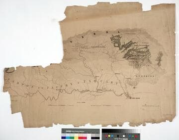
Rio Grande do Sul Province, Brazil, west of Porto Alegre
Rare Books
Kirkpatrick Catalogue entry: "2462 [Campos do Jacuhy e Taquary]. Lipsia, Instituto lithographico de H. Kunsch, 1861. 1 sheet. [see cabinet]."Map either untitled or the title was on a now-missing portion. Probably obtained while Burton was in South America between 1865 and 1868. MS notes: Burton (map cabinet) Campos 2462.. Prime meridian: GM. Relief: hachures. Graphic Scale: Leagues. Projection: Cylindrical. Printing Process: Lithography.
623636

Nova carta chorographica do Imperio do Brazil : reduzida pelo bacharel Pedro Torquato Xr. de Brito, Tenente Coronel Gro. do Corpo d'Engenheiros e Socio effectivo do Instituto Polytechnico Brasileiro, da que foi confeccionada pelo Coronel Conrado Jacob de Niemeyer, e outros officiaes engenheiros em 1856
Rare Books
Kirkpatrick Catalogue entry: "2475 Niemeyer, C. J. de Nova carta chorographica do Imperio do Brazil ...1856. [Rio de Janeiro], Gravada na Litha. do Archo. Militar por Alvaro e Pereira, 1867. 1 sheet. [see p.]."MS label on verso reads "Coronel Niemeyer's Map of Brazil." Probably obtained while Burton was in South America between 1865 and 1868. Prime meridian: Rio de Janeiro. Relief: hachures. Graphic Scale: Leagues, kilometers. Projection: Cylindrical. Printing Process: Lithography. Verso Text: Label: Coronel Niemeyer's Map of Brazil. Stamp: Kensington Public Libraries.
623649

Nova planta da cidade do Rio de Janeiro
Rare Books
Kirkpatrick Catalogue entry: "2468 Laemmert, E. & H., publisher. Nova planta de ciudad do Rio de Janeiro. [Rio de Janeiro], 1864. 1 sheet. [see p.]." Publishers sticker inside front cover. The legend to the left of and below the map lest different squares, streets, public buildings, etc. Probably obtained while Burton was in South America between 1865 and 1868. Street and building index in surround.. Prime meridian: GM. Relief: hachures. Projection: Plane. Printing Process: Lithography. Verso Text: Stamps: Kensington Public Libraries.
623641