Visual Materials
Battlefields in front of Nashville where the United States Forces commanded by Major General Geo. H. Thomas defeated and routed the Rebel Army under General Hood December 15th & 16th 1864
You might also be interested in
Image not available
Battlefields in front of Nashville where the United States forces commanded by Major General Geo. H. Thomas defeated and routed the Rebel army under General Hood December 15th & 16th 1864
Rare Books
194224 v. 1 no. 18
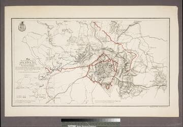
Map illustrating the Siege of Atlanta, GA. by the U.S. Forces, under Command of Maj. Gen. W. T. Sherman from the passage of Peach Tree Creek, July 19th 1864 to the movement upon the Enemy's lines of communication south of Atlanta, August 26, 1864
Visual Materials
Kashnor notes, "Indicates, by red and blue lines, the respective positions of the Federal and Confederate forces." Appeared in info from RLIN record. Shield of Corps of Engineers (?) upper left.. Relief: hachures. Graphic Scale: Miles. Projection: Plane. Printing Process: Lithography. Verso Text: MS notes: 049 348.
105:398 S

Map for the Interior Travels through America, delineating the March of the Army
Visual Materials
Kashnor notes, "A lithograph from the original map. Shows the coast from Casco Bay to James River, and indicates the line of march of the British forces, and the extent of parole allowed to British and German officers held prizoner by the Americans." Kashnor dates at [circa 1780] but more probably this early lithograph was made in the early 1800's. Some distortion through transfer from original map. Original engraver and appeared in information from RLIN record. Kashnor has this item numbered as 105*. Lithographed copy does not have colors of original map, see RLIN record.. Prime meridian: London. Relief: pictorial. Graphic Scale: Miles, statute. Projection: Cylindrical. Printing Process: Lithography. Verso Text: MS note: 105.
105:105 M
Image not available
A New and Accurate Map of Peru, and the country of the Amazones
Visual Materials
Kashnor notes, "Indicates Parima Lake and the famour city of El Dorado two degrees North of the Equator." Kashnor dates as ca. 1760. RLIN record suggests 1747 as publication data. Cartouche: Decorative shell.. "Drawn from the most authentick French Maps &c. and Regulated by Astronomical Observations. By Eman. Bowen." "No. 118 (lower left)" Prime meridian: London. Relief: pictorial. Graphic Scale: Leagues. Projection: Pseudocylindrical. Printing Process: Copper engraving. Other Features: Cartouche. Verso Text: MS note: 933.
105:933 M
Image not available
Mexico and Guatemala, shewing the Position of the Mines
Visual Materials
Kashnor notes, "Indicates the respective positions of the gold and silver mines, and the stations at which provincial councils of mines held their sittings." Prime meridian: GM. Relief: hachures. Graphic Scale: Miles. Projection: Pseudocylindrical. Printing Process: Copper engraving. Verso Text: MS note: 518.
105:518 M
Image not available
Map of Massachusetts Proper Compiled from Actual Surveys made by Order of the General Court, and under the inspection of Agents of their appointment, By Osgood Carleton
Visual Materials
Kashnor notes, "Includes a fine engraved view drawn by G. Graham, and indicates the positions of roads, boundaries, public buildings, rivers, ponds, bridges, minerals, &c." "Engraved by Joseph Callender and Samuel Hill, Boston, 1801. Vignette drawn by G. Graham." Cartouche: large cartouche with Indian figure, pastoral scene.. Prime meridian: London, Washington. Relief: no. Graphic Scale: Miles. Projection: Cylindrical. Printing Process: Copper engraving. Other Features: Cartouche. Verso Text: MS notes: No. 32 32 P6 Map of Massachusetts, 1801. Carleton. Map of Massachusetts By Osgood Carleton. 1801. 534..
105:534 M