Visual Materials
New Chart of the Coast of New England, Nova Scotia, New France, or Canada, with the Islands of Newfoundld. Cape Breton St. John's &c. Done from the original Publish'd in 1744. at Paris, by Monsr. N. Bellin, Engineer to the Marine Office
You might also be interested in
Image not available
Map of New England and Nova Scotia; with part of New York, Canada, and New Britain & the adjacent Islands of New Found Land Cape Breton &c. by Tho. Kitchin Geogr
Visual Materials
Kashnor notes, "A scarce map issued at the time of the Old French War." RLIN record gives date and published in information. Cartouche: harbor/forest scene. MS note: 280 (on backing). Prime meridian: London. Relief: pictorial. Graphic Scale: Miles. Projection: Cylindrical. Watermark: Seal circular device. Printing Process: Copper engraving. Other Features: Cartouche. References: Kershaw 708; McCorkle 758.7. Verso Text: MS note: 280 (on backing).
093:280 S
Image not available
New Map of Canada, Also the North Parts of New England and New York; with Nova Scotia and Newfound Land. From the Sr. Robert with Improvements
Visual Materials
Kashnor dates as ca. 1760. Submap of the Great Lakes. [Shows south limits of Canada including everything north of the 41st parallel west of Michigan.] See 105:671 for an earlier version of this map. McCorkle gives appeared in information. Submap: Supplement for the Lakes of Canada. MS note: 303 (on backing). Prime meridian: London. Relief: pictorial. Graphic Scale: Miles, leagues. Projection: Pseudocylindrical. Printing Process: Copper engraving. Other Features: Sub-maps. References: Kershaw 370; McCorkle 759.3. Verso Text: MS note: 303 (on backing).
093:303 S
Image not available
Plan of the City & Harbour of Louisburg; shewing that part of Gabarus Bay in which the English landed, also their Encampment during the Siege in 1745
Visual Materials
Kashnor notes, "a scarce little map with inset map of the Island of Cape Breton." Kershaw identifies appeared in information. Submap; Map of the Island of Cape Breton. MS note: 319 (on backing).. Prime meridian: London. Relief: pictorial. Graphic Scale: Miles. Projection: Plane. Printing Process: Copper engraving. Other Features: Sub-maps. References: Kershaw 910. Verso Text: MS note: 319 (on backing)..
093:319 S
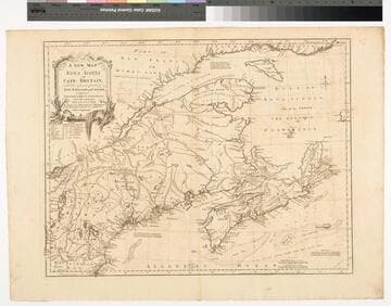
A New Map of Nova Scotia and Cape Britain. with the adjacent parts of New England and Canada, Composed from a great number of actual Surveys ; and other materials Regulated by many new Astronomical Observations of the Longitude as well as Latitude ; with an Explanation
Visual Materials
Kashnor notes, "The first issue of Jefferys' map. It was re-issued twenty years later by Sayer and Bennett." Kershaw states this is the second state of Jefferys map. Prime meridian: London, Ferro. Relief: pictorial. Graphic Scale: Miles, leagues. Projection: Pseudocylindrical. Watermark: I Ville Ary under IHS Crowned fleur-di-lis over LVC. Printing Process: Copper engraving. Other Features: Cartouche. References: Kershaw 739; McCorkle 755.20. Verso Text: MS note: 668.
105:668 M
Image not available
A New and Correct Chart of the Coast of New Foundland, from Cape Raze to Cape Bonavista, with Chebucto Harbour in Nova Scotia done from the latest Observations
Visual Materials
Kashnor notes, "a fine chart, one of the earliest published charts of Newfoundland." Lightly printed. Kashnor dates as ca. 1752. Kershaw notes this plate was used till 1775 when "it was extremely worn and the impressions for several of the last editions are poor." Kershaw gives appeared in information. Submaps: Trinity Harbour; St. Johns Harbour; Chedabucto Harbour in Nova Scotia. Relief: no. Graphic Scale: Leagues, Miles. Projection: Plane. Printing Process: Copper engraving. Other Features: Sub-maps. References: Kershaw 523. Verso Text: MS note: 562.
105:562 M

Canada Orientale nell' America Settentrionale descritta dal P. Mro. Coronelli M. C. Cosmografo della Geren Republica de Venetia dedicata Alli Reverendi Padri Li P. P. Minori Conventuali del Monastero insigne de S. Francesco di Bologna
Visual Materials
Kashnor notes, "Showing the mouth of the St. Laurence, with Newfoundland, Cape Breton Island, and parts of Nova Scotia and the Coast of Canada." Kashnor dates ca. 1690. Coronelli was active in Venice. Fish entwined cartouche.. Relief: no. Graphic Scale: Miles, leagues. Projection: Cylindrical. Watermark: Small circled fleur-di-lis.. Printing Process: Copper engraving. Other Features: Cartouche. References: Kershaw (Canada) 162. Verso Text: MS note: 251.
093:251 M