Visual Materials
C1.3 - Maps

You might also be interested in
C1.3 - Maps
Visual Materials
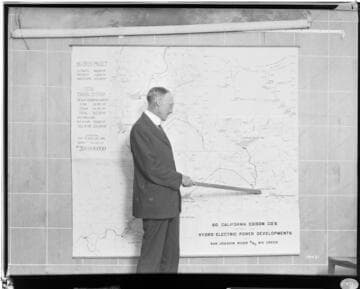
C1.3 - Maps - Mr. Barre at map showing proposed development of the San Joaquin River and Big Creek. He is pointing to Florence Lake Reservoir.
photCL SCE 02 - 10431

C1.3 - Maps
Visual Materials
C1.3 - Maps - Relief map of Big Creek-San Joaquin River Development [existing & proposed].
photCL SCE 02 - 13284
C1.3 - Maps
Visual Materials
C1.3 - Maps - Big Creek development [profile] horse power chart [proposed, includes PH 6 & 7]
photCL SCE 02 - 05449

C1.3 - Maps
Visual Materials
C1.3 - Maps - Big Creek development Kilowatt output profile chart [proposed, includes PH 6 & 7]
photCL SCE 02 - 05450

C1.3 - Maps
Visual Materials
C1.3 - Maps - Profile maps showing Big Creek-San Joaquin Power project.
photCL SCE 02 - 13274

C1.3 - Maps
Visual Materials
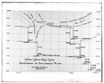
C1.3 - Maps - Profile drawing of Big Creek facilities showing tunnels and pipelines.
photCL SCE 02 - 18019