Visual Materials
Map of the Louisville and Great Southern Railroad line & connections

You might also be interested in

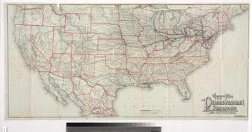
Map of the Atchison Topeka and Santa Fe Railroad and its leased lines
Visual Materials
Image of a map of the United States showing the railroad routes from Kansas to California and Mexico of the Atchison, Topeka, and Santa Fe, and connecting lines; map verso contains panels with railroad timetables, promotional descriptions, and fold-up map covers with images of a grenadier soldier holding a sword and charging across the country in a helmet with a locomotive head lamp and billowing smoke stack, and a view of a steam locomotive approaching on tracks inset among palm trees.
priJLC_TRAN_001053

Map of the Texas & Pacific Railway and connections. : The true Southern route to and from California is via El Paso and the Texas & Pacific Railway
Visual Materials
Image of a map of Texas and bordering states showing the route and connecting lines of the Texas & Pacific Railway, with an inset map in the upper right corner of most of the continental United States, Mexico, and Cuba, and an inset in the lower right corner of a black and white photograph captioned, “Harvest scene on line of the Texas & Pacific Railway in Texas,” with men on mule-driven farm equipment in a field; map verso contains panels with fold-up map covers, railroad timetables and promotional descriptions.
priJLC_TRAN_001060

The short line across the continent. : Map of the great central route between the Atlantic and Pacific : Michigan Central and Great Western Railways
Visual Materials
Image of a map of a portion of the Eastern United States from as far west as Omaha, Nebraska, showing railroad routes of the Michigan Central and Great Western Railroad and connecting lines, with a vignette in the lower left corner of the Niagara Falls Suspension Bridge and an inset map in the lower right corner of the Western United States showing railroad routes and titled, "Map between the Missouri River and the Pacific Ocean"; map verso contains panels with the fold-up map covers, promotional descriptions including an image of a freight car for the Great Central Route's Blue Line, and timetables.
priJLC_TRAN_001174

Map of the great air line route, Ohio & Mississippi Railway and connections
Visual Materials
Image of a map of a portion of the Eastern and Midwestern United States from as far west as Denver, Colorado, to the Atlantic Ocean, showing the railroad route of the Ohio & Mississippi Railroad and connecting lines; with a vignette of the East Bridge captioned "View of the bridge across the Mississippi at St. Louis." and printed information about the bridge to the left of map; map verso contains panels with the fold-up map covers, promotional descriptions, timetables, a vignette of the East Bridge with a steamboat and horse-drawn wagons and pedestrians in the foreground, and a vignette of a side elevation of a Pullman drawing room and sleeping car.
priJLC_TRAN_001170

Illinois Central Railroad: New Orleans through line. : No change of cars from Chicago to New Orleans
Visual Materials
Image of a map of the Midwestern and Eastern United States showing the railroad routes and connecting lines of the Illinois Central Railroad from Chicago, Illinois, outward to Yankton, South Dakota, Cincinnati, Ohio, and New Orleans, Louisiana; map verso contains fold-up map covers and panels with promotional descriptions and timetables.
priJLC_TRAN_001145
General map of the Pennsylvania Railroad and its connections
Visual Materials
Image of a map of most of the continental United States and part of Mexico showing the main routes and connecting lines of the Pennsylvania Railroad, with routes and railroad stations named; map verso contains 16 panels with railroad timetables, promotional descriptions, a vignette of the interior of a Pennsylvania Railroad Dining Car with well-dressed diners being served by African-American servers, a vignette of a Pullman sleeping car with passengers sitting in seats, including a woman reading and a girl, and inset with an image of a sleeping birth and a man shining shoes; folding map cover contains a vignette of a train on the Horseshoe Curve in the Allegheny Mountains and an American eagle with wings displayed standing on a shield with an "E Pluribus Unum" banner.
priJLC_TRAN_001061