Visual Materials
Iran : Azerbaijan

You might also be interested in
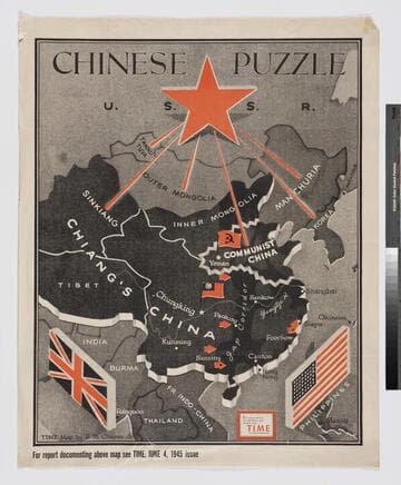
Chinese puzzle
Visual Materials
"Time map by R.M. Chapin, Jr."--lower left corner of the map. "Enlargement of original map drawn for Time, the weekly newsmagazine"--inset text box, lower right of map. "For report documenting above map see Time, June 4, 1945 issue"--text below map, large text, left corner. No scale given.
priJHK 00110

Blood on four flags
Visual Materials
There is a diagram at the very top showing the Netherlands connected to the Netherlands East Indies by 9,900 sea miles. "Time map by R.M. Chapin, Jr."--lower left corner of the map. "Enlargement of original map drawn for Time, the weekly newsmagazine"--inset text box, lower left of map. "For report documenting above map see Time, October 29, 1945 issue"--text below map, large text, right corner. Scale is 8 3/4 inches = 200 miles.
priJHK 00111
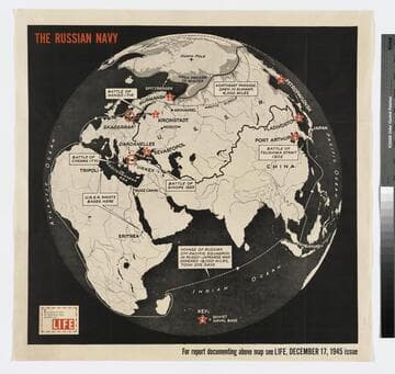
The Russian Navy
Visual Materials
"Enlargement of original map drawn for Life"--inset text box, lower left of map. "For report documenting above map see Life, December 17, 1945 issue"--text below map, large text, right corner. No scale given.
priJHK 00113
Image not available
Iran : Azerbaijan
Visual Materials
Artists: Chapin, R. M. Publishers: Time Inc.
priJHK 00112

A map showing the network of European railroads
Visual Materials
"[Affixed label for D.F. Robertson Travel Insurance] through all Europe from Paris ... via French National Railroads"--text box with an image of the Eiffle Tower and train, the outline of France in green in the background, upper right corner of the map. "Printed in U.S.A., Z.J. Kantin Company, N.Y."--text, small type, lower left corner, below image. "Specially prepared by the French National Railroads / offered to travel agents — A.S.T.A. Convention — 1949"--text, lower right corner, below image. Two labels for D.F. Robertson Travel Insurance, Los Angeles, are affixed to the map, one along the lower edge, the other in blank space left for an agent's, or agencies, stamp in the upper right corner of the map within the inset text box.
priJHK 00118

Travel around America : new - fast American built electric ships
Visual Materials
"All new steamers / S.S. California / S.S. Virginia / S.S. Pennsylvania"--text, inset box, lower left corner.
priJHK 00121