Visual Materials
State of Virginia from the best Authorities, by Samuel Lewis. 1794
You might also be interested in
Image not available
State of North Carolina from the best Authorities, &c. by Samuel Lewis
Visual Materials
Kashnor notes, "An interesting map, showing the old roads and pathways." Kashnor dates as [1795]. Longitude shown from London and Philadelphia. Rosenthal lists a Samuel Lewis as being active in Philadelphia in the late 1700's. Prime meridian: London, Philadelphia. Relief: pictorial. Graphic Scale: Miles, American. Projection: Plane. Printing Process: Copper engraving. Verso Text: MS note: 375..
093:375 S
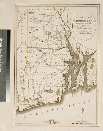
State of Rhode Island; compiled from the Surveys and Observations of Caleb Harris
Visual Materials
Kashnor notes, "The first issue of this map [1796], second issue was in 1818." McCorkle dates as 1795 and gives appeared in information. Wheat & Brun note state 1. MS notes: 581 Mus. Col. #93. Relief: no. Graphic Scale: Miles. Projection: Plane. Watermark: Device. Printing Process: Copper engraving. References: McCorkle R795.2; Wheat & Brun 250, state 1..
093:581 S
Image not available
Map of the Country betwen Albemarle Sound and Lake Erie, comprehending the whole of Virginia, Maryland, Delaware and Pennsylvania, with parts of several other of the United States of America. Engraved for the Notes on Virginia. The country on the eaternside of the Alleganey Mountains is taken from Fry and Jefferson's Map of Virginia, and Scull's map of Pennsylvania, which were constructed manily on actual survey; that on the westernside of the Alleganey, is taken from Hutchins, who went over the principal water courses, with a compass and log line, correcting his work by observations of latitude: additions have been made where they could be made on sure ground
Visual Materials
Kashnor notes, "Shows a particularly good map of the Ohio country where it is named 'a new state.'" Prime meridian: Philadelphia. Relief: pictorial. Graphic Scale: Miles. Projection: Cylindrical. Printing Process: Copper engraving. Verso Text: MS notes: 521 Mus. cat. 93.
093:521 M
Image not available
New Map of Virginia from the best Authorities: by T. Kitchin Geogr
Visual Materials
Jolly confirms publication date. MS note: 93/592 (on backing). Prime meridian: London, Philadelphia. Relief: pictorial. Graphic Scale: Miles. Projection: Cylindrical. Printing Process: Copper engraving. References: Jolly, Lond-205;. Verso Text: MS note: 592 (on backing).
093:592 S
Image not available
Map of the State of Pennsylvania, by Reading Howell, MDCCXCII (1792)
Visual Materials
Kashnor notes, "The original issue of this map, with the declaration of Samuel Caldwell, dated, 'the eleventh day of January, in the fifteenth year of Independence of the United States of America.'" Wheat & Brun shows numerous states of this map. This appears to be state 2, but publication location is uncertain. Cartouche: wreath around dedication.. Prime meridian: Washington. Relief: hachures. Graphic Scale: Miles. Projection: Cylindrical. Printing Process: Copper engraving. Other Features: Cartouche. References: Wheat & Brun 434. Verso Text: MS note: 572/ Mus. Col. 93.
093:572 M
Image not available
Correct Map of Virginia
Visual Materials
Kashnor dates as ca. 1790. Prime meridian: London, Philadelphia. Relief: hachures. Graphic Scale: Miles. Projection: Cylindrical. Printing Process: Copper engraving. Verso Text: MS note: 588/93 .
093:588 S