Visual Materials
General Chart of the Western Ocean

You might also be interested in
Image not available
Generall Chart of the Western Ocean
Rare Books
See also 105:164 in Museum Book Store Collection. Kashnor notes, " showing the coast of North America from Newfoundland to Florida, locating the Colonies." Kashnor dates as c.1750. Sales slip with this map optimistically suggests c.1700. Folder from Anderson Gallery enclosed. This appears to be one of two sheets since 105:164 extends further to the east. Prime meridian: London. Relief: no. Graphic Scale: Leagues. Projection: Mercator. Printing Process: Copper engraving. Verso Text: MS notes: 150600 D. Huckley in Aylis Street (sp.?).
150600

New and Correct Chart of the Western and Southern Oceans, Shewing the Variation of the Compass
Visual Materials
Kashnor notes, "Shows all the east coast of North America, locating the colonies, and all of South America." Two side letterpress panels describe the use of the chart and note it's derivation from Halley's 1700 chart. Prime meridian: London. Relief: no. Projection: Mercator. Printing Process: Etching. Verso Text: MS note: 165.
105:165 M

Chart of North Atlantic Ocean with tracks of the Shipping to West Indies, North America &c
Visual Materials
Kashnor notes, "Shows the coast of North America from Hudson's Straits, locating the states on the seaboard." Shows routes of US ship Insurgent, Route of Nelson in 1805 in addition to trade routes. Also shows nonexistant "New Sea" between Hudson's Bay and Straits. Prime meridian: Ferro. Relief: no. Projection: Mercator. Printing Process: Copper engraving. Verso Text: MS note: 160.
105:160 M
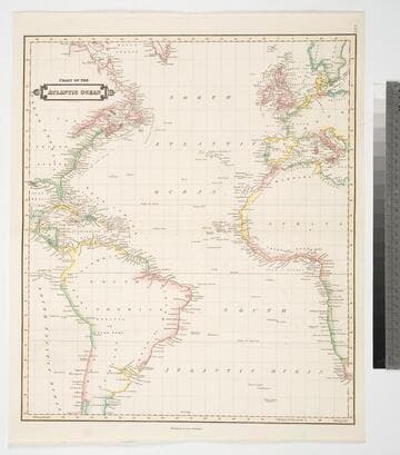
Chart of the Atlantic Ocean
Visual Materials
Kashnor notes, "Shewing the American Coast from Hudson's Strait to C. Bahias in Patagonia, and the European and African Coast from the Faeroe Islands to Cape Town." Prime meridian: GM. Relief: no. Projection: Mercator. Printing Process: Copper engraving. Verso Text: MS notes: 168 Chart of the Atlantic Ocean..
105:168 M

Bowles's New Pocket-Map of the Atlantic or Western Ocean, Laid down from the Latest Discoveries, and Regulated by Numerous Astronomical Observations
Visual Materials
Kashnor notes, "Showing the coast of America from the Straits of Bell Isle to Florida, with the West Indies and part of South America. Locates all the American Colonies. Issued for the use of mariners during the Revolution." Longitude from London at top, in hours and minutes from London on bottom. Palairet's Atlas from RLIN information. Two compass roses.. Prime meridian: London. Relief: no. Graphic Scale: No. Projection: Mercator. Watermark: Crowned fluer-di-lis J. Whatman. Printing Process: Copper engraving. Other Features: Art Work. Verso Text: MS notes: 62 35.
105:062 M

Chart of the Atlantic or Western Ocean, from the parallel of 3 degrees to 59 degrees 30' North Latitude
Visual Materials
Prime meridian: GM. Relief: no. Projection: Mercator. Printing Process: Copper engraving. Verso Text: MS notes: 35 162.
105:162 M