Rare Books
Generall Chart of the Western Ocean
You might also be interested in
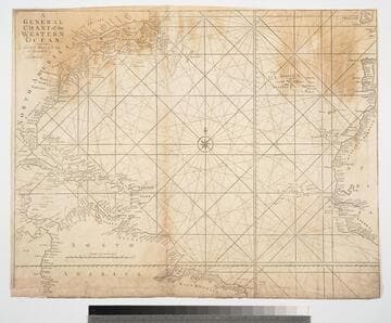
General Chart of the Western Ocean
Visual Materials
Kashnor notes, " showing the coast of North America from Newfoundland to Florida, locating the Colonies." Kashnor dates as c.1750. Prime meridian: London. Relief: no. Graphic Scale: Leagues. Projection: Mercator. Printing Process: Copper engraving. Verso Text: MS note: 164.
105:164 M

New and Correct Chart of the Western and Southern Oceans, Shewing the Variation of the Compass
Visual Materials
Kashnor notes, "Shows all the east coast of North America, locating the colonies, and all of South America." Two side letterpress panels describe the use of the chart and note it's derivation from Halley's 1700 chart. Prime meridian: London. Relief: no. Projection: Mercator. Printing Process: Etching. Verso Text: MS note: 165.
105:165 M
Image not available
America
Visual Materials
Kashnor notes, "Shows a good map of the North-West, locating San Francisco, Monterey, Santa Cruz, San Gabriel, Columbia River, &c." Prime meridian: GM. Relief: pictorial. Projection: Pseudocylindrical. Printing Process: Engraving. Verso Text: Ms notes: Cat 105 201.
105:201 M
Image not available
Chart of the Harbour of Boston, with the Soundings, Sailing-Marks and Other Directions
Visual Materials
Kashnor notes, "From the indications, Ruins of Charlestown, this map must have been executed about 1776." RLIN record suggests ca. 1777 and give publisher information. This map may be a source map for 105:064M. Relief: hachures. Graphic Scale: Miles, nautical. Projection: Plane. Watermark: Crowned fleur-di-lis. Printing Process: Copper engraving. Verso Text: MS notes: 65 2.
105:065 M
Image not available
Pacific Ocean, by J. Arrowsmith
Visual Materials
Kashnor notes, "Shows the North-West coast of Alaska, locating Port San Francisco, also with a second title of Port Sir Franc. Drake, Columbia River, with Fort Vancouver and Clatsop, also a map of Australasia and Polynesia." Vancouver Island labeled: Quadra & Vancouver's. Sandwich Islands [Hawaii] noted as: dis'c. by Mendana & named Isles de la Mesa. Map extends beyond neatline.. Prime meridian: GM. Relief: hachures. Graphic Scale: No. Projection: Cylindrical. Printing Process: Engraving. Verso Text: MS. note: 58.
093:058 M
Image not available
Pacific Ocean, by J. Arrowsmith
Visual Materials
Kashnor notes, "Includes the western coast of America from Behring Sea to Cape Horn. It is a very correct map, locating San Francisco, Monterey Bay, San Carlos, Santa Barbara, also Clatsop and Fort Vancouver on the Columbia." Vancouver Island labeled: Quadra & Vancouver's. Sandwich Islands [Hawaii] noted as: dis'c. by Mendana & named Isles de la Mesa. See 093:058M for an earlier copy. Map extends beyond neatline.. Prime meridian: GM. Relief: hachures. Graphic Scale: No. Projection: Cylindrical. Printing Process: Engraving. Verso Text: MS. note: 290 1851.
105:290 M