Rare Books
Plan of the Bay and Island of Mobile
You might also be interested in

A new map of the island of Cuba with correct plans of all the principal ports and harbours it contains
Rare Books
Removed from Universal Museum, November 1762, p 603. (Described in Cuba In Old Maps by Emilio Cueto, 1999.) Submaps: Ten Ports and harbors. Prime meridian: Ferro, London. Relief: pictorial. Graphic Scale: Leagues, miles. Projection: Cylindrical. Printing Process: Copper engraving.
295817
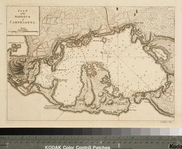
Plan of the Harbour of Carthagena
Rare Books
Appeared in Jefferys' A description of the Spanish islands and settlements..., 1762. MS notes: X65565 !2-1/2 x 8-3/4. Prime meridian: GM. Relief: hachures. Graphic Scale: Miles. Projection: Cylindrical. Printing Process: Copper engraving.
65565

St. Christophers, or St. Kitts, surveyed By Anthony Ravell Esqr. Surveyor General of the Islands of St. Christophers, Nevis, & Montserrat. Engraved by Thomas Jefferys Geographer to the King
Visual Materials
See 093:827M for an earlier copy. Vignette: Nevis from shipboard Submap: Nevis, by Thomas Jefferys.. Prime meridian: London, Ferro. Relief: hachures. Graphic Scale: Miles, leagues. Projection: Cylindrical. Printing Process: Copper engraving. Other Features: VignettesSub-maps. Verso Text: MS notes: 828.
093:828 M

Caribee Islands and Guayana
Visual Materials
Kashnor notes, "A fine old chart. Isla Fonseca, or San Pedro, is inserted twice, in latitudes 12 and 14, according to conflicting authorities." "Drawn by L. Delarochette. Engraved by Thomas Jefferys, Geographer to his Royal Highness the Prince of Wales." Prime meridian: Ferro, Lizard. Relief: pictorial. Graphic Scale: Leagues. Projection: Cylindrical. Printing Process: Copper engraving. Verso Text: MS notes: 944 34.
105:944 M
Image not available
A General Chart of the West India Islands with the Adjacent Coasts of the Spanish Continent, by L. S. de la Rochette. MDCCXCVI (1796)
Visual Materials
Prime meridian: GM. Relief: no. Graphic Scale: Leagues. Projection: Cylindrical. Printing Process: Copper engraving. Verso Text: MS note: 952.
105:952 M

Island of Hispaniola called by the French St. Domingo. Subject to France & Spain. from the best Authorities by Thomas Jefferys, Geographer to His Majesty
Visual Materials
RLIN record shows Jefferys as "geographer to his Royal Highness the Prince of Wales." Prime meridian: London, Ferro. Relief: pictorial. Graphic Scale: Miles, leagues. Projection: Cylindrical. Watermark: Crowned fleur-di-lis JWhatman. Printing Process: Copper engraving. Verso Text: MS note: 418.
105:418 S