Manuscripts
Diseño del Rancho Los Felis

You might also be interested in
Image not available
Rancho Los Felis: S61. Potrero of the Rancho Los Felis [5 maps connected
Manuscripts
4 of the maps are labeled Potrero of the Rancho Los Felis but reference different pages from the field book (27, 29, 31, 34), some with color highlighting, courses, distances, stations, showing Los Angeles canal, reseroir ditch; the fifth map: "El Potrero or irrgable flat of the Rancho Los Feliz... showing that part which is disevident in a deed [Baldwins]. Title supplied by cataloger.
mssSolano SR_Box_21(09).08
Image not available
Rancho Los Felis
Manuscripts
Within letter to James Lick, San Francisco, verso of first page with hachures indicating Hills of the Felis Rancho, River Los Angeles. Title supplied by cataloger.
mssSolano SR_Box_21(08).01

Rancho los Felis : Wilson, Feliz, Partridge, Hunter, and Mills & Wicks properties
Manuscripts
Southeast corner of Rancho los Felis; based on surveys of 1882-1885. Inset 6 x 6 in.: stake #2 of Rancho los Felis boundary featuring river, hachures. Surveyed at the request of John Grant. Var.14° 45' East. Mills & Wicks to Hunt Trustee recorded 110 acres. Title supplied by cataloger.
mssSolano SR_Map_0077

Plat of the Rancho Sausal-Redondo
Manuscripts
Bordered by Shoalwater Bay, ranchos San Pedro, Tajauta, La Ballona, Aguaje de la Centinela, Cienega o Paso de la Tijera. Containing 48,750 2/100 Acres. Color highlighting; section numbers, lines of previous surveys. Copy certified on September 24, 1870, by Sherman Day in the case of the "Tajauta, Sausal Redondo". Letter "B" in upper right corner. Alt title supplied by cataloger.
mssSolano SR_Map_0261

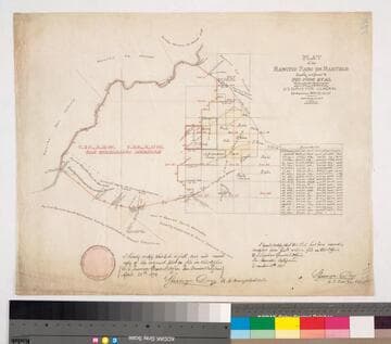
Rancho Los Felis : showing Lyons, Wilson, and Felis properties and the Canal & Reservoir Co. ditch
Manuscripts
NW corner of city. Names referenced on map: Anastacio Felis, Spencer Wilson, Cyrus Lyons.. Hachures: land features including sandstone ledges; little blue colored pencil. "Back of map" map: Alameda & San Fernando Str.: Sewer, Dec. 10, 1880: Ann Street to Sotello. Title supplied by cataloger.
mssSolano SR_Map_0072.01A
Plat of the Rancho Paso de Bartolo finally confirmed to Pio Pico et al
Manuscripts
Bordered by Ranchos Santa Gertrudes, San Antonio, La Merced, Potrero de Felipe Lugo, La Puente, San Gabriel River. Copy certified by Sherman Day, Surveyor General; Var. 15° 30' East. Inset with table of boundaries. T.2S. R.12W., T.2S. R.11W. S.B.M.
mssSolano SR_Map_0097